1900s (20th Century) Maps of Allegany, New York
Explore 30 historic maps of Allegany from the 1900s (20th Century). These maps offer a rare glimpse into what life looked like during the 1900s — showing old roads, neighborhoods, homes, and landmarks that have changed or disappeared over time.
Whether you're researching your family's past, planning a metal detecting trip, or studying how Allegany's landscape evolved across the 1900s, these high-resolution maps are a powerful tool for exploring the history of this region.
- Focus on a specific era: All maps on this page are from the 1900s, giving you a focused view of this time period.
- See what’s changed: Compare century-old streets, trails, and buildings to today's modern landscape using overlays and satellite layers.
- Research with precision: Use these maps for genealogy, historical research, land use analysis, or educational projects.
- View, download, or print: Maps are fully viewable online in high resolution, and can be downloaded or printed for your own records.
Start exploring Allegany's history through authentic maps from the 1900s. This is your window into the past.
Allegany, NY maps
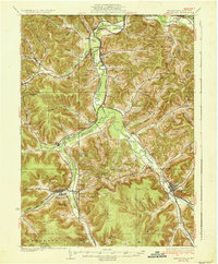
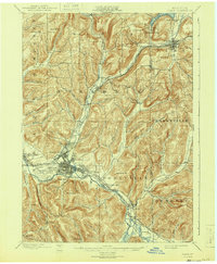
(30)- 1900 Map of Salamanca
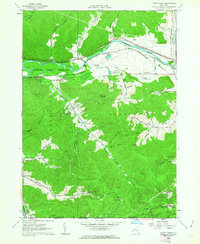
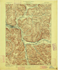 1900 Salamanca1900 Print · USGSCattaraugus County's rail and timber era is documented here as it appeared in the late 1890s, centered on the river-bend hub of Salamanca. Genealogists and historians can trace the early boundaries of the Allegheny Indian Reservation and locate vanished rail stops like Irvine Mills and Peth.6 unique versions available
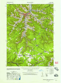
 - 1924 Map of Bradford
 1924 Bradford1924 Print · USGSMcKean County's industrial heartland is captured here in the mid-1920s, showing a landscape defined by timber, chemicals, and heavy rail. Trace early infrastructure from the KINZUA VIADUCT to family-named landmarks like Corwins Corners and Bells Camp.2 unique versions available
 - 1926 Map of Bradford
 1926 Bradford1926 Print · USGSNorthwestern Pennsylvania's oil and timber country comes alive in the mid-twenties, centered on the bustling industrial valley of Bradford. Researchers can trace the path of the Bradford Electric Ry, find local homesteads near Custer City, or locate the famed Kinzua Viaduct.4 unique versions available
 - 1933 Map of Smethport, 1960 Print
 1933 Smethport1960 Print · USGSNorthern Pennsylvania’s river valleys were centers of industry and transit in the early 1930s as rail lines followed the winding water gaps. Genealogists can trace family roots through numerous valley schoolhouses like Bush Hill Sch and rural settlements including Duke Center and Turtlepoint.
 - 1937 Map of Smethport
 1937 Smethport1937 Print · USGSMcKean County's river valleys and oil-country settlements are captured here in the mid-1930s as the regional rail network still connected remote hollows. Genealogists and historians can trace the exact locations of local schools like Newell Creek Sch, old family landmarks such as Devils Den, and the rural layout of Smethport.3 unique versions available
 - 1938 Map of Salamanca, 1954 Print
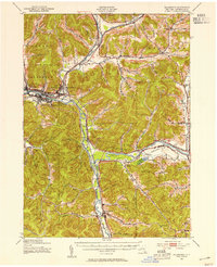 1938 Salamanca1954 Print · USGSIn the late 1930s, this portion of Cattaraugus County was a critical rail and river hub where the Allegheny River meets major transit lines. Researchers can trace the layout of the Allegheny Reservation and locate vanished stop points like Irvine Mills and Kill Buck.2 unique versions available
 - 1938 Map of Olean, 1955 Print
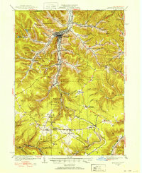
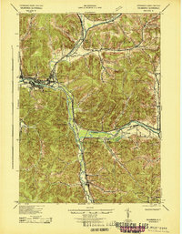
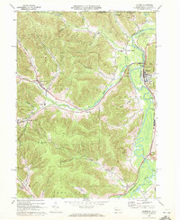
 1938 Olean1955 Print · USGSOlean and the Allegheny River valley are shown here just before the mid-century, defined by a dense network of Pennsylvania and Erie rail lines. Local historians can trace the development of Westons Mills and the industrial layout near North Olean or locate the Oil Spring Indian Reservation.3 unique versions available
 - 1941 Map of Bradford, 1958 Print
 1941 Bradford1958 Print · USGSMcKean County's industrial landscape was at its peak during the early 1940s, marked by a dense network of mountain railroads and small oil-country settlements. Genealogists can trace family roots through numerous rural landmarks like Songbird Sch, Irishtown, and Davis Gifford PO.2 unique versions available
 - 1943 Map of Olean
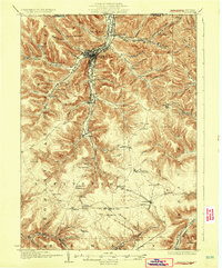
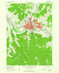
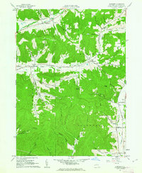
 1943 Olean1943 Print · USGSCattaraugus County in the late nineteenth century was a corridor of burgeoning rail and industry along the Allegheny. Researchers can trace the path of the Penna. R.R. through old settlements like Hinsdale and Westons Mills, or locate early landmarks like Rock City.
 - 1943 Map of Salamanca
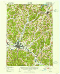
 1943 Salamanca1943 Print · USGSCattaraugus County during the early 1940s reveals a landscape defined by the intersection of the Allegheny River and major rail lines. Genealogists and rail historians can trace the paths of the Erie and Baltimore and Ohio railroads through Salamanca and Killbuck.
 - 1944 Map of Bradford
 1944 Bradford1944 Print · USGSMcKean County and the New York borderlands are shown here during the mid-1940s, a period defined by heavy rail traffic and mountain settlements. You can trace old property lines and rural schoolhouses like Bolivar Run Sch, or find the Gifford PO and Big Shanty Sta along the timber and oil valleys.
 - 1957 Map of Warren, 1964 Print
 1957 Warren1964 Print · USGSThe northern Pennsylvania oil and timber country comes into focus in the mid-fifties, showing the region before modern highway expansions. Trace the industrial rail networks of the Pennsylvania RR and the early Allegheny River Reservoir near Warren and Oil City.4 unique versions available
 - 1958 Map of Warren
 1958 Warren1958 Print · USGSNorthern Pennsylvania’s timber and oil country is captured here during the late fifties, showing the interplay of industrial valleys and vast state forests. Genealogists can trace family connections across the Cornplanter Indian Reservation or through rail hubs like Oil City and Saint Marys.
 - 1959 Map of Warren
 1959 Warren1959 Print · USGSNorthern Pennsylvania's oil and timber country comes alive in this late-fifties study of the forest-clad plateaus. Trace the historic Cornplanter (Indian Reservation), the sprawling Oil Field, and the rail lines of the Pennsylvania RR.2 unique versions available
 - 1960 Map of Buffalo
 1960 Buffalo1960 Print · USGSWestern New York and the Niagara Peninsula thrive during the mid-twentieth century industrial peak. Genealogists and historians can trace family-named points and early settlements from Dunkirk Light to the Allegany Indian Reservation.
 - 1961 Map of Olean, 1962 Print
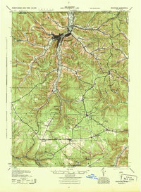
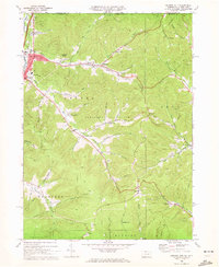
 1961 Olean1962 Print · USGSOlean and Allegany are shown in the early sixties as bustling rail and river hubs near the Pennsylvania border. Genealogists and local historians can trace the grounds of St Bonaventure University, Mt View Cemetery, and the local oil field.3 unique versions available
 - 1961 Map of Hinsdale, 1963 Print
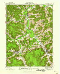
 1961 Hinsdale1963 Print · USGSCattaraugus County in the early 1960s shows a landscape of deep valleys defined by the meeting of Ischua Creek and Oil Creek. Genealogists and historians can trace rail history along the Erie Lackawanna Railroad or locate local landmarks like Maplehurst, Hinsdale Cem, and Union Valley Ch.
 - 1961 Map of Knapp Creek, 1963 Print
 1961 Knapp Creek1963 Print · USGSCattaraugus County in the early sixties reveals a landscape shaped by the Bradford Oil Field and the winding Allegheny River. Genealogists and local historians can trace the rural road networks and settlements of Vandalia, Chipmunk, and Knapp Creek alongside numerous oil and gas wells.2 unique versions available
 - 1961 Map of Humphrey, 1963 Print
 1961 Humphrey1963 Print · USGSThe hills of Cattaraugus County in the early sixties reveal a landscape of secluded hollows and small-scale oil extraction. Genealogists and historians can trace old homesteads and landmarks like St Pacificus Ch, Sugartown, and the Fivemile Cem.4 unique versions available
 - 1962 Map of Buffalo, 1980 Print
 1962 Buffalo1980 Print · USGSThe Niagara Frontier and Western New York are captured here in the early sixties, showing the vital industrial and maritime nexus between the U.S. and Canada. Researchers can trace the path of the Welland Canal, locate the Allegany Indian Reservation, or find family sites near Chautauqua Lake.2 unique versions available
 - 1967 Map of Buffalo
 1967 Buffalo1967 Print · USGSWestern New York and the Lake Erie shoreline are shown here during the mid-1960s industrial peak. Researchers can trace the massive rail networks of the Erie Railroad, locate the Cattaraugus Indian Reservation, or find historic sites like Fort Erie.
 - 1969 Map of Eldred, 1972 Print
 1969 Eldred1972 Print · USGSMcKean County and the New York border region are captured here in the late sixties, showing the active Bradford Oil Field and the Allegheny River corridor. Researchers can trace family sites at Lamphier Cem, find the Township Sch, or explore the rail network through Larabee and West Eldred.3 unique versions available
 - 1969 Map of Derricks City, 1972 Print
 1969 Derricks City1972 Print · USGSThe Pennsylvania-New York borderlands near McKean County are shown here in the late sixties, centered on the intensive petroleum operations of the Bradford Oil Field. Genealogists and researchers can trace old school sites like Lincoln School and family landmarks such as Corwins Corners.3 unique versions available
 - 1971 Map of Warren
 1971 Warren1971 Print · USGSNorth Central Pennsylvania is captured here in the early seventies, showing a landscape defined by industrial centers and massive state forests. Genealogists and historians can trace the rail lines of the Penn Central and Erie Lackawanna connecting towns like Warren, Kane, and Du Bois.
 - 1971 Map of Hinsdale
 1971 Hinsdale1971 Print · USGSCattaraugus County in the early sixties maintains its character as a transport hub where the Pennsylvania and Erie Lackawanna railroads meet. Trace family roots through local sites like Union Valley Ch and the Maple Grove Cem.
Showing maps 1-25 of 30
Top cities near Allegany
- Olean historical maps
- Bradford historical maps
- Salamanca historical maps
- Portville historical maps
- Cuba historical maps
- Franklinville historical maps
See more
Top neighborhoods of Allegany
- Chipmunk historical maps
- Knapp Creek historical maps
- Four Mile historical maps
- Rock City historical maps
- Harrisburg historical maps
- Crestview historical maps
See more
Frequently asked questions
- What are the different types of historical maps available for Allegany?
- What is the oldest map of Allegany?
- Where can I purchase historical maps of Allegany for my home or office?
- Where can I download high-res historical maps of Allegany?
- Are there historical topographic maps available for Allegany?
- Is there historical aerial imagery available for Allegany?
- Where are historical maps of Allegany sourced from?