1900s (20th Century) Maps of Jimerson Town, Salamanca
Explore 9 historic maps of Jimerson Town from the 1900s (20th Century). These maps offer a rare glimpse into what life looked like during the 1900s — showing old roads, neighborhoods, homes, and landmarks that have changed or disappeared over time.
Whether you're researching your family's past, planning a metal detecting trip, or studying how Jimerson Town's landscape evolved across the 1900s, these high-resolution maps are a powerful tool for exploring the history of this region.
- Focus on a specific era: All maps on this page are from the 1900s, giving you a focused view of this time period.
- See what’s changed: Compare century-old streets, trails, and buildings to today's modern landscape using overlays and satellite layers.
- Research with precision: Use these maps for genealogy, historical research, land use analysis, or educational projects.
- View, download, or print: Maps are fully viewable online in high resolution, and can be downloaded or printed for your own records.
Start exploring Jimerson Town's history through authentic maps from the 1900s. This is your window into the past.
Jimerson Town, Salamanca maps
(9)- 1922 Map of Randolph, 1955 Print
 1922 Randolph1955 Print · USGSCattaraugus County in the early twenties shows a landscape of river-valley commerce and mountain parkland. Genealogists can locate dozens of country schoolhouses like Archer Hill School and vanished rail stops such as Onoville Sta and Elkdale Sta.2 unique versions available
 - 1923 Map of Randolph
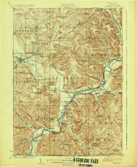 1923 Randolph1923 Print · USGSCattaraugus County's southern borderlands are captured here in the early 1920s, showing a landscape defined by the winding Allegheny River and burgeoning state park. Genealogists can trace family footprints at the Wolf Run Elko PO, Oldtown School, or the many rural schoolhouses like Bunker Hill School.4 unique versions available
 - 1943 Map of Randolph
 1943 Randolph1943 Print · USGSCattaraugus County's river-and-rail corridor is captured here in the 1940s, highlighting the Allegheny Indian Reservation and the rugged lands of South Valley. Genealogists and researchers can trace rural life through numerous district landmarks like the Bone Run School, Wolf Run Elko PO, and the chemical plant at Red House.
 - 1960 Map of Buffalo
 1960 Buffalo1960 Print · USGSWestern New York and the Niagara Peninsula thrive during the mid-twentieth century industrial peak. Genealogists and historians can trace family-named points and early settlements from Dunkirk Light to the Allegany Indian Reservation.
 - 1962 Map of Little Valley, 1964 Print
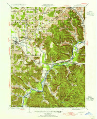
 1962 Little Valley1964 Print · USGSCattaraugus County is shown in the early 1960s as the Allegheny Reservoir began to alter the river valley. Genealogists and researchers can trace the Allegany Indian Reservation boundary, locate the Jimmersontown Ch, and follow the Erie-Lackawanna rail lines.5 unique versions available
 - 1962 Map of Buffalo, 1980 Print
 1962 Buffalo1980 Print · USGSThe Niagara Frontier and Western New York are captured here in the early sixties, showing the vital industrial and maritime nexus between the U.S. and Canada. Researchers can trace the path of the Welland Canal, locate the Allegany Indian Reservation, or find family sites near Chautauqua Lake.2 unique versions available
 - 1967 Map of Buffalo
 1967 Buffalo1967 Print · USGSWestern New York and the Lake Erie shoreline are shown here during the mid-1960s industrial peak. Researchers can trace the massive rail networks of the Erie Railroad, locate the Cattaraugus Indian Reservation, or find historic sites like Fort Erie.
 - 1973 Map of Buffalo
 1973 Buffalo1973 Print · USGSWestern New York and Ontario's Golden Horseshoe meet in the early seventies, spanning from the industrial waterfronts of Buffalo to the hills of Allegany State Park. Trace the paths of the Welland Canal and Erie Lackawanna railroad through the lakefront towns of Dunkirk and Port Colborne.
 - 1986 Map of Olean
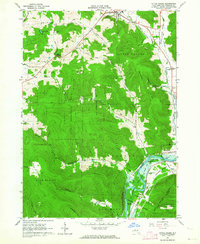
 1986 Olean1986 Print · USGSThe Southern Tier and northern Pennsylvania border are captured here in the mid-1980s as the regional rail and river economy evolved. Genealogists and local historians can trace family-named sites across the Allegany Indian Reservation, identify old Oil Field tracts, or locate landmarks like St Bonaventure University and the Tannery.2 unique versions available
End of results
Showing maps 1-9 of 9
Top cities near Jimerson Town
- Bradford historical maps
- Allegany historical maps
- Salamanca historical maps
- Franklinville historical maps
- Randolph historical maps
- Machias historical maps
See more
Frequently asked questions
- What are the different types of historical maps available for Jimerson Town?
- What is the oldest map of Jimerson Town?
- Where can I purchase historical maps of Jimerson Town for my home or office?
- Where can I download high-res historical maps of Jimerson Town?
- Are there historical topographic maps available for Jimerson Town?
- Is there historical aerial imagery available for Jimerson Town?
- Where are historical maps of Jimerson Town sourced from?