1940s Maps of Scott, New York
Explore 4 historic maps of Scott from the 1940s. These maps offer a rare glimpse into what life looked like during the 1940s — showing old roads, neighborhoods, homes, and landmarks that have changed or disappeared over time.
Whether you're researching your family's past, planning a metal detecting trip, or studying how Scott's landscape evolved across the 1940s, these high-resolution maps are a powerful tool for exploring the history of this region.
- Focus on a specific era: All maps on this page are from the 1940s, giving you a focused view of this time period.
- See what’s changed: Compare century-old streets, trails, and buildings to today's modern landscape using overlays and satellite layers.
- Research with precision: Use these maps for genealogy, historical research, land use analysis, or educational projects.
- View, download, or print: Maps are fully viewable online in high resolution, and can be downloaded or printed for your own records.
Start exploring Scott's history through authentic maps from the 1940s. This is your window into the past.
Scott, NY maps
(4)- 1943 Map of Spafford
 1943 Spafford1943 Print · USGSThe steep shorelines of Skaneateles and Otisco Lakes appear here during the mid-1940s. Genealogists and local historians can trace family locations through numerous named cemeteries like Kelloggsville Cem and schools such as School No 7.
 - 1943 Map of Otisco Valley
 1943 Otisco Valley1943 Print · USGSCentral New York's glacial lake country is captured here during the early 1940s, showing the rural communities of the Tully and Otisco valleys. Genealogists can locate family burial grounds like St Patricks Cem and tracing old school districts and Salt Wells.
 - 1943 Map of Sempronius, 1953 Print
 1943 Sempronius1953 Print · USGSThe rural uplands of Cayuga County come alive in this wartime survey of the Finger Lakes region. Genealogists and local historians can locate several district schools and family landmarks like Morse Mill, Lake Como, and Sand Hill Cem.2 unique versions available
 - 1944 Map of Homer
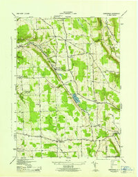
 1944 Homer1944 Print · USGSThe Tioughnioga River valleys in the 1940s were centers of agriculture and rail transport. Genealogists can trace family footprints at Atwater Cem or locate old schoolhouses like School No 10 and the former County Farm.
End of results
Showing maps 1-4 of 4
Top cities near Scott
- Onondaga historical maps
- Cortland historical maps
- Dryden historical maps
- Cortlandville historical maps
- Skaneateles historical maps
- Pompey historical maps
See more
Top neighborhoods of Scott
Frequently asked questions
- What are the different types of historical maps available for Scott?
- What is the oldest map of Scott?
- Where can I purchase historical maps of Scott for my home or office?
- Where can I download high-res historical maps of Scott?
- Are there historical topographic maps available for Scott?
- Is there historical aerial imagery available for Scott?
- Where are historical maps of Scott sourced from?