Old Maps of Fergusonville, Davenport for Metal Detecting
Plan your next treasure hunt with 14 historic maps of Fergusonville. Find old homesites, ghost towns, trails, and gathering spots that may be lost to time — perfect for identifying promising metal detecting locations.
- Locate forgotten sites: Uncover places like long-lost settlements, abandoned rail lines, or gathering spots.
- Plan better hunts: Use map overlays combined with LiDAR or satellite views to narrow in on historically rich areas.
- Made for detectorists: Thousands of hobbyists use these maps to discover relics, coins, and hidden history.
Use these historic maps to boost your research and find new opportunities beneath the surface of Fergusonville.
Fergusonville, Davenport maps
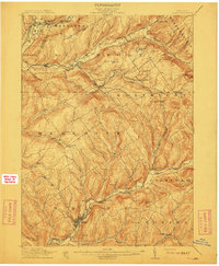
(14)- 1909 Map of Delhi, 1963 Print
 1909 Delhi1963 Print · USGSDelaware County at the turn of the century is a landscape of valley railroads and high ridgeline farms. Genealogists and researchers can trace family lands near Elk Creek Church, follow the old Ulster and Delaware RR line, or locate early sites in Delhi and Meridale.
 - 1911 Map of Delhi
 1911 Delhi1911 Print · USGSDelaware County during the first decade of the twentieth century shows a landscape of rail-driven river towns and high hill farms. You can trace the historic routes of the Ulster and Delaware RR and locate local landmarks like the Elk Creek Church and Wakaqua Falls.5 unique versions available
 - 1943 Map of Davenport, 1960 Print
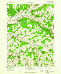 1943 Davenport1960 Print · USGSDelaware County during the 1940s is defined by its rural valley settlements and the essential New York Central rail corridor. Genealogists can trace family roots through upland landmarks like Kortright Center, Fergusonville, and the Covenanter Cem.3 unique versions available
 - 1945 Map of Davenport
 1945 Davenport1945 Print · USGSMid-century Delaware County is captured here in the hills of Davenport and Kortright just as the dairy economy and rail lines defined rural life. Genealogists can trace family footprints at Kortright Station, Hoseaville, or the old Covenanter Cem.
 - 1948 Map of Binghamton, 1980 Print
 1948 Binghamton1980 Print · USGSCentral New York and the Southern Tier thrive in the late 1940s as a hub of rail traffic and mountain industry. Researchers can trace historic transit lines like the Erie Railroad through Binghamton or find old valley settlements near Oneonta and Delhi.
 - 1950 Map of Binghamton
 1950 Binghamton1950 Print · USGSBinghamton and the surrounding Southern Tier are shown in the mid-century era, highlighting the intricate rail and river networks that drove local industry. Researchers can trace the path of the Erie Railroad and locate landmarks from Otsego Lake to Sidney Mountain.2 unique versions available
 - 1958 Map of Binghamton
 1958 Binghamton1958 Print · USGSCentral New York in the late fifties was a network of manufacturing cities and river valleys connected by vital rail lines. Genealogists and historians can trace family roots in Oneonta, Norwich, and Cooperstown or locate long-standing farms along Schoharie Creek.
 - 1963 Map of Binghamton
 1963 Binghamton1963 Print · USGSThe Southern Tier and Catskill peaks are shown in the early sixties as new reservoirs reshaped the valleys. Trace historic rail corridors like the Erie Lackawanna RR and explore lakeside settlements such as Cooperstown and Oneonta.
 - 1986 Map of Pepacton Reservoir
 1986 Pepacton Reservoir1986 Print · USGSThe Catskills in the mid-eighties show a landscape shaped by the Pepacton Reservoir and protected wilderness. Local historians can trace mountain rail corridors like the Delaware & Ulster RR and locate high-elevation landmarks from Slide Mountain to Hunter Mountain.2 unique versions available
 - 2010 Map of Davenport, 2010 Print
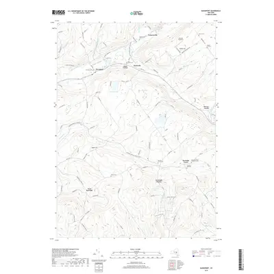
 2010 Davenport2010 Print · USGSCovers Fergusonville, including Davenport, Maryland, and other nearby areas
 - 2013 Map of Davenport, 2013 Print
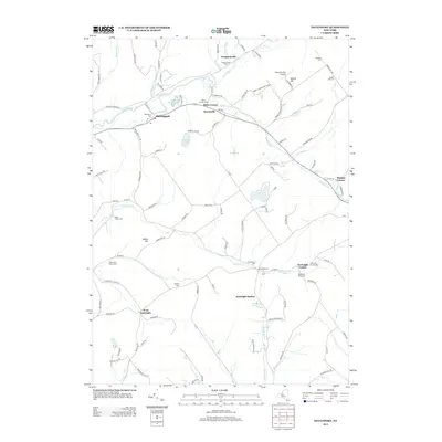 2013 Davenport2013 Print · USGSCovers Fergusonville, including Davenport, Maryland, and other nearby areas
 - 2016 Map of Davenport, 2016 Print
 2016 Davenport2016 Print · USGSCovers Fergusonville, including Davenport, Maryland, and other nearby areas
 - 2019 Map of Davenport, 2019 Print
 2019 Davenport2019 Print · USGSCovers Fergusonville, including Davenport, Maryland, and other nearby areas
 - 2023 Map of Davenport, 2023 Print
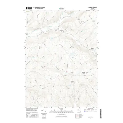
 2023 Davenport2023 Print · USGSDavenport and the surrounding Charlotte Valley are shown here in the early twenty-first century, a landscape of family farms and creek-side hamlets. Genealogists can trace lineage through numerous sites like Fergusonville Cem, Quaker Hill Cem, and Kortright Center.
End of results
Showing maps 1-14 of 14
Top cities near Fergusonville
- Oneonta historical maps
- Oneonta historical maps
- Delhi historical maps
- Otsego historical maps
- Davenport historical maps
- Milford historical maps
See more
Frequently asked questions
- What are the different types of historical maps available for Fergusonville?
- What is the oldest map of Fergusonville?
- Where can I purchase historical maps of Fergusonville for my home or office?
- Where can I download high-res historical maps of Fergusonville?
- Are there historical topographic maps available for Fergusonville?
- Is there historical aerial imagery available for Fergusonville?
- Where are historical maps of Fergusonville sourced from?