1900s (20th Century) Maps of Pillar Point, Brownville
Explore 7 historic maps of Pillar Point from the 1900s (20th Century). These maps offer a rare glimpse into what life looked like during the 1900s — showing old roads, neighborhoods, homes, and landmarks that have changed or disappeared over time.
Whether you're researching your family's past, planning a metal detecting trip, or studying how Pillar Point's landscape evolved across the 1900s, these high-resolution maps are a powerful tool for exploring the history of this region.
- Focus on a specific era: All maps on this page are from the 1900s, giving you a focused view of this time period.
- See what’s changed: Compare century-old streets, trails, and buildings to today's modern landscape using overlays and satellite layers.
- Research with precision: Use these maps for genealogy, historical research, land use analysis, or educational projects.
- View, download, or print: Maps are fully viewable online in high resolution, and can be downloaded or printed for your own records.
Start exploring Pillar Point's history through authentic maps from the 1900s. This is your window into the past.
Pillar Point, Brownville maps
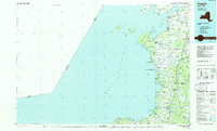
(7)- 1942 Map of Henderson Bay
 1942 Henderson Bay1942 Print · USGSJefferson County’s shoreline comes alive in the early 1940s, highlighting the military presence at the historic Madison Barracks. Researchers can trace old lakeside schoolhouses and family cemeteries like Stone Cem or explore the waterfront detail near Sackets Harbor.
 - 1959 Map of Henderson Bay, 1960 Print
 1959 Henderson Bay1960 Print · USGSThe Jefferson County shoreline in the late fifties is defined by its deep maritime history and expanding recreation areas. Researchers can trace the layout of Sackets Harbor and locate family landmarks such as Sherwin Bay Cem or Boultons Beach.
 - 1960 Map of Rochester
 1960 Rochester1960 Print · USGSThe Lake Ontario shoreline in the late fifties was a bustling corridor of rail and water commerce. Genealogists and historians can trace the path of the New York Central through canal towns like Newark or explore the coastal landmarks around Sackets Harbor.2 unique versions available
 - 1961 Map of Rochester, 1973 Print
 1961 Rochester1973 Print · USGSThe Lake Ontario shoreline and Finger Lakes frontier are shown here at the height of the mid-century infrastructure boom. Genealogists and historians can trace the rail-and-road evolution from Sackets Harbor down to the New York State Thruway, passing through centers like Pulaski and Adams Center.3 unique versions available
 - 1965 Map of Rochester
 1965 Rochester1965 Print · USGSUpstate New York's industrial heartland is captured here during a period of significant growth between the Great Lakes and the Finger Lakes. Genealogists and historians can trace the evolution of canal towns and rail hubs from Rochester to Syracuse, noting features like the Erie Canal and the New York State Thruway.
 - 1980 Map of Henderson Bay, 1983 Print
 1980 Henderson Bay1983 Print · USGSThe Jefferson County shoreline comes alive in the early 1980s, where the historic military grounds of Sackets Harbor meet the waters of Lake Ontario. Genealogists and historians can trace family plots at Stone Cem or Ferry Cem and explore the rugged points from Pillar Point to Stony Point.
 - 1985 Map of Pulaski
 1985 Pulaski1985 Print · USGSThe eastern shores of Lake Ontario in the mid-1980s showcase a landscape of protected wetlands and historic harbor towns. Trace the paths of the CONRAIL railroad and explore the coastal heritage of Sackets Harbor, Port Ontario, and Selkirk Shores State Park.2 unique versions available
End of results
Showing maps 1-7 of 7
Top cities near Pillar Point
- Watertown historical maps
- Watertown historical maps
- Brownville historical maps
- Adams historical maps
- Clayton historical maps
- Ellisburg historical maps
See more
Frequently asked questions
- What are the different types of historical maps available for Pillar Point?
- What is the oldest map of Pillar Point?
- Where can I purchase historical maps of Pillar Point for my home or office?
- Where can I download high-res historical maps of Pillar Point?
- Are there historical topographic maps available for Pillar Point?
- Is there historical aerial imagery available for Pillar Point?
- Where are historical maps of Pillar Point sourced from?