1940s Maps of Jewettville, Hounsfield
Explore 1 historic maps of Jewettville from the 1940s. These maps offer a rare glimpse into what life looked like during the 1940s — showing old roads, neighborhoods, homes, and landmarks that have changed or disappeared over time.
Whether you're researching your family's past, planning a metal detecting trip, or studying how Jewettville's landscape evolved across the 1940s, these high-resolution maps are a powerful tool for exploring the history of this region.
- Focus on a specific era: All maps on this page are from the 1940s, giving you a focused view of this time period.
- See what’s changed: Compare century-old streets, trails, and buildings to today's modern landscape using overlays and satellite layers.
- Research with precision: Use these maps for genealogy, historical research, land use analysis, or educational projects.
- View, download, or print: Maps are fully viewable online in high resolution, and can be downloaded or printed for your own records.
Start exploring Jewettville's history through authentic maps from the 1940s. This is your window into the past.
Jewettville, Hounsfield maps
(1)- 1943 Map of Sackets Harbor
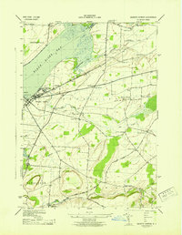 1943 Sackets Harbor1943 Print · USGSSackets Harbor and its military waterfront are captured in the early 1940s during a period of active defense and local growth. Genealogists can trace family names through rural junctions like Baggs Corners and identify several rural schoolhouses or the Muskalonge Cem.
End of results
Showing maps 1-1 of 1
Top cities near Jewettville
- Le Ray historical maps
- Watertown historical maps
- Watertown historical maps
- Brownville historical maps
- Adams historical maps
- Clayton historical maps
See more
Frequently asked questions
- What are the different types of historical maps available for Jewettville?
- What is the oldest map of Jewettville?
- Where can I purchase historical maps of Jewettville for my home or office?
- Where can I download high-res historical maps of Jewettville?
- Are there historical topographic maps available for Jewettville?
- Is there historical aerial imagery available for Jewettville?
- Where are historical maps of Jewettville sourced from?