1950s Maps of Lewis County, New York
Explore 19 historic maps of Lewis County from the 1950s. These maps offer a rare glimpse into what life looked like during the 1950s — showing old roads, neighborhoods, homes, and landmarks that have changed or disappeared over time.
Whether you're researching your family's past, planning a metal detecting trip, or studying how Lewis County's landscape evolved across the 1950s, these high-resolution maps are a powerful tool for exploring the history of this region.
- Focus on a specific era: All maps on this page are from the 1950s, giving you a focused view of this time period.
- See what’s changed: Compare century-old streets, trails, and buildings to today's modern landscape using overlays and satellite layers.
- Research with precision: Use these maps for genealogy, historical research, land use analysis, or educational projects.
- View, download, or print: Maps are fully viewable online in high resolution, and can be downloaded or printed for your own records.
Start exploring Lewis County's history through authentic maps from the 1950s. This is your window into the past.
Lewis County, NY maps
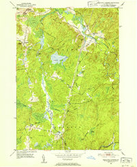
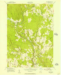
(19)- 1950 Map of Utica, 1951 Print
 1950 Utica1951 Print · USGSCentral New York in the post-war era showcases the industrial Mohawk Valley and the pristine Adirondack interior. Researchers can trace transportation networks like the New York Central Railroad and find early Cold War sites such as Griffiss Air Force Base.
 - 1951 Map of Antwerp
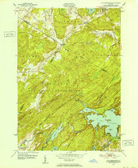
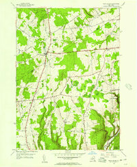
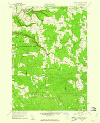
 1951 Antwerp1951 Print · USGSAntwerp and its surroundings in the early fifties were shaped by the intersection of the New York Central Railroad and the expansive Pine Camp Military Reservation. Researchers can trace old district boundaries and local landmarks like Hillside Cem, School No 15, and the course of the Indian River.
 - 1951 Map of North Wilna
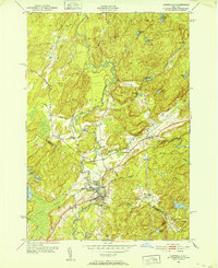
 1951 North Wilna1951 Print · USGSThe Jefferson and Lewis County line area is shown here in the early fifties, featuring the large Pine Camp Military Reservation and its surrounding rural hamlets. Local researchers can trace family-named sites like Ormiston Corners, old district schoolhouses, and the Natural Bridge Cemetery near the Indian River.
 - 1951 Map of Ogdensburg
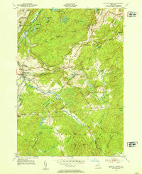
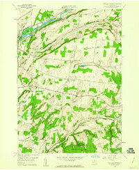
 1951 Ogdensburg1951 Print · USGSThe St. Lawrence frontier and the North Country are captured here during the post-war era, from the river ports to the high Adirondacks. Genealogists and historians can trace the rail-and-river economy through Ogdensburg, the Rutland rail lines, and Potsdam.
 - 1951 Map of Remington Corners, 1952 Print
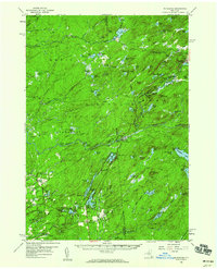
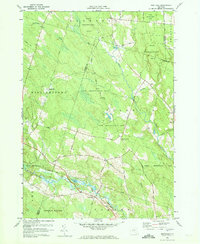
 1951 Remington Corners1952 Print · USGSThe Adirondack foothills of Lewis County appear in the early fifties as a landscape of isolated river settlements and mountain timberlands. Genealogists and hikers can trace old family-named crossroads like Tinney Corners and Oswegatchie Corners, or locate historic mill sites at Kimball Mill.4 unique versions available
 - 1951 Map of Lake Bonaparte, 1952 Print
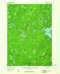
 1951 Lake Bonaparte1952 Print · USGSIn the North Country during the early fifties, this area was defined by the intersection of civilian life and the growing Camp Drum Military Reservation. Genealogists and historians can trace old homesteads near Kellogg Corners, quiet lakeside landings at Lake Bonaparte, and the rural crossroads of Alpina.5 unique versions available
 - 1951 Map of Harrisville, 1952 Print
 1951 Harrisville1952 Print · USGSThe Adirondack foothills of St. Lawrence County come into focus in the early fifties, documenting a world of riverside rail and remote pond systems. Genealogists and historians can trace the New York Central corridor through Harrisville and locate the Garrison Cem near the West Branch Oswegatchie River.4 unique versions available
 - 1951 Map of Natural Bridge, 1953 Print
 1951 Natural Bridge1953 Print · USGSThe Jefferson and Lewis county line comes alive in the early fifties, showing a landscape shaped by the New York Central railroad and military expansion. Genealogists can locate family landmarks like Hillside Cem, Blanchard Corners, and the settlement at Natural Bridge.4 unique versions available
 - 1953 Map of Ogdensburg
 1953 Ogdensburg1953 Print · USGSThe North Country and St. Lawrence Valley are shown here in the early fifties, just as the region’s rail-and-river economy remained in full swing. Genealogists and historians can trace family-named corners and rural hubs along the Rutland railroad or locate heritage sites near Ogdensburg, Potsdam, and the St Regis Indian Reservation.
 - 1955 Map of Point Rock, 1957 Print
 1955 Point Rock1957 Print · USGSThe border of Lewis and Oneida Counties in the 1950s reveals a quiet landscape of rural industry and ethnic settlements. Genealogists can trace family roots through the Prussian Settlement, old mills like Swancott Mill, and local landmarks such as St Anns Ch.4 unique versions available
 - 1955 Map of West Leyden, 1957 Print
 1955 West Leyden1957 Print · USGSThe upland forests and headwaters of the Mohawk River are captured here in the mid-1950s, showing the rural character of the Oneida and Lewis County line. Researchers can locate local burial sites like Thornton Cem and trace the path of the historic Black River Canal.2 unique versions available
 - 1955 Map of Boonville, 1957 Print
 1955 Boonville1957 Print · USGSBoonville and the surrounding Oneida County highlands are captured here in the mid-1950s, showing a landscape of deep river gorges and upland farms. Researchers can locate historic landmarks like North Steuben Ch, Egypt Cem, and the old Fairgrounds.3 unique versions available
 - 1955 Map of Florence, 1957 Print
 1955 Florence1957 Print · USGSThe Tug Hill region on the Oneida and Lewis county line is shown here in the mid-fifties, dominated by state reforestation tracts and rural hamlets. Researchers can trace family roots at St Marys Ch or locate old school sites and burials like Gregory Cem and School No 1.3 unique versions available
 - 1957 Map of Utica
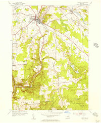
 1957 Utica1957 Print · USGSCentral New York and the Adirondack foothills are captured here in the mid-fifties, showing a landscape defined by the Mohawk River corridor and the growing highway system. Genealogists and researchers can trace the rail lines of the New York Central and locate communities from Lowville to Gloversville.
 - 1957 Map of Number Four, 1964 Print
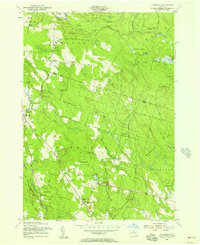
 1957 Number Four1964 Print · USGSThe western Adirondacks during the mid-1950s reveal a landscape of managed wilderness and remote settlements. Researchers can trace historic access routes like Prentice Road or locate the Lookout Tower near Number Four and Stillwater.4 unique versions available
 - 1958 Map of Mc Keever, 1960 Print
 1958 Mc Keever1960 Print · USGSThe Herkimer and Oneida county lines meet in the heart of the Adirondacks during the late fifties, where rail lines and river branches shaped the local economy. Genealogists can locate family-named sites like Hubbards and Porters Corners or trace the New York Central through Minnehaha.4 unique versions available
 - 1959 Map of Rutland Center, 1960 Print
 1959 Rutland Center1960 Print · USGSJefferson County dairy lands and upland hollows are captured here in the late fifties, as rural life centered on crossroads like Tylersville and Burrs Mills. Researchers can locate family homesteads near Maple Hill Cem or trace the old New York Central line along the Black River.2 unique versions available
 - 1959 Map of Barnes Corners, 1961 Print
 1959 Barnes Corners1961 Print · USGSThe Tug Hill Plateau at the edge of the Jefferson and Lewis County line shows a landscape of deep gulfs and massive reforestation efforts in the late fifties. Researchers can locate remote settlements like Seven-by-Nine and Barnes Corners or trace families at Newton Cem.3 unique versions available
 - 1959 Map of Westdale, 1961 Print
 1959 Westdale1961 Print · USGSThe rural border of Oneida and Oswego counties comes into focus in the late 1950s, showing a landscape defined by state reforestation and quiet crossroads. Genealogists can trace family footprints at Johnson Cem or follow the path of the Old Railroad Grade near Westdale.3 unique versions available
End of results
Showing maps 1-19 of 19
Top cities of Lewis County
- Lowville historical maps
- Croghan historical maps
- New Bremen historical maps
- Denmark historical maps
- Watson historical maps
- West Turin historical maps
See more
Frequently asked questions
- What are the different types of historical maps available for Lewis County?
- What is the oldest map of Lewis County?
- Where can I purchase historical maps of Lewis County for my home or office?
- Where can I download high-res historical maps of Lewis County?
- Are there historical topographic maps available for Lewis County?
- Is there historical aerial imagery available for Lewis County?
- Where are historical maps of Lewis County sourced from?