1970s Maps of Clarkson, New York
Explore 5 historic maps of Clarkson from the 1970s. These maps offer a rare glimpse into what life looked like during the 1970s — showing old roads, neighborhoods, homes, and landmarks that have changed or disappeared over time.
Whether you're researching your family's past, planning a metal detecting trip, or studying how Clarkson's landscape evolved across the 1970s, these high-resolution maps are a powerful tool for exploring the history of this region.
- Focus on a specific era: All maps on this page are from the 1970s, giving you a focused view of this time period.
- See what’s changed: Compare century-old streets, trails, and buildings to today's modern landscape using overlays and satellite layers.
- Research with precision: Use these maps for genealogy, historical research, land use analysis, or educational projects.
- View, download, or print: Maps are fully viewable online in high resolution, and can be downloaded or printed for your own records.
Start exploring Clarkson's history through authentic maps from the 1970s. This is your window into the past.
Clarkson, NY maps
(5)- 1971 Map of Hamlin, 1973 Print
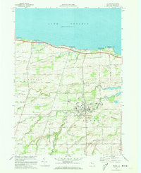
 1971 Hamlin1973 Print · USGSThe Lake Ontario shoreline near Hamlin and Kendall Mills is captured here in the early 1970s as a quiet agricultural and recreational corridor. Researchers can trace family history through local landmarks like St Johns Sch, Lakeside Cem, and the path of the Penn Central railroad.
 - 1971 Map of Hilton, 1973 Print
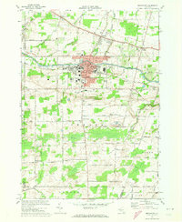
 1971 Hilton1973 Print · USGSMonroe County's lakefront and agricultural interior are captured here in the early seventies as the village of Hilton flourished. Researchers can trace historic schools and cemeteries such as Williams Jr High Sch and Parma Union Cem, or locate the path of the Penn Central rail line.2 unique versions available
 - 1971 Map of Brockport, 1973 Print
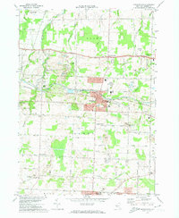
 1971 Brockport1973 Print · USGSBrockport and the surrounding township of Sweden are captured here in the early seventies, centered on the historic canal and a growing university campus. Genealogists can trace family names across Lake View Cemetery or search for ancestral roots in West Sweden and Clarkson.2 unique versions available
 - 1971 Map of Spencerport, 1974 Print
 1971 Spencerport1974 Print · USGSMonroe County's canal and rail corridor is captured here in the early seventies, showing a landscape defined by the ERIE CANAL and the village of Spencerport. Researchers can trace local history through the many rural schools, family-named roads like Vroom Road, and cemeteries including Maple Grove Cem.2 unique versions available
 - 1978 Map of Hamlin
 1978 Hamlin1978 Print · USGSMonroe County's lakeshore and farming hinterlands are captured here in the late seventies. Researchers can trace rural lineages through the locations of Lakeside Cem, St Johns Sch, and established crossroads like Morton and Kendall Mills.
End of results
Showing maps 1-5 of 5
Top cities near Clarkson
- Rochester historical maps
- Greece historical maps
- North Greece historical maps
- Henrietta historical maps
- Gates historical maps
- Chili historical maps
See more
Top neighborhoods of Clarkson
Frequently asked questions
- What are the different types of historical maps available for Clarkson?
- What is the oldest map of Clarkson?
- Where can I purchase historical maps of Clarkson for my home or office?
- Where can I download high-res historical maps of Clarkson?
- Are there historical topographic maps available for Clarkson?
- Is there historical aerial imagery available for Clarkson?
- Where are historical maps of Clarkson sourced from?