1950s Maps of Riga, New York
Explore 4 historic maps of Riga from the 1950s. These maps offer a rare glimpse into what life looked like during the 1950s — showing old roads, neighborhoods, homes, and landmarks that have changed or disappeared over time.
Whether you're researching your family's past, planning a metal detecting trip, or studying how Riga's landscape evolved across the 1950s, these high-resolution maps are a powerful tool for exploring the history of this region.
- Focus on a specific era: All maps on this page are from the 1950s, giving you a focused view of this time period.
- See what’s changed: Compare century-old streets, trails, and buildings to today's modern landscape using overlays and satellite layers.
- Research with precision: Use these maps for genealogy, historical research, land use analysis, or educational projects.
- View, download, or print: Maps are fully viewable online in high resolution, and can be downloaded or printed for your own records.
Start exploring Riga's history through authentic maps from the 1950s. This is your window into the past.
Riga, NY maps
(4)- 1950 Map of Churchville, 1952 Print
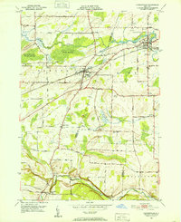 1950 Churchville1952 Print · USGSThe rural borderlands of Genesee and Monroe Counties come alive in this mid-century survey of the New York Central rail corridor. Researchers can trace historic farmstead locations and early settlements like Stone Church, Jericon Corners, and the scenic Buttermilk Falls.2 unique versions available
 - 1950 Map of Clifton, 1952 Print
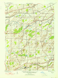 1950 Clifton1952 Print · USGSMonroe County was a network of rail-side hamlets and creekside settlements at mid-century. Researchers can trace the legacy of local families through landmarks like Clifton Cem and Oatka Cem or the grounds of Roberts Wesleyan College.3 unique versions available
 - 1952 Map of Brockport
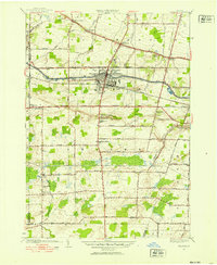 1952 Brockport1952 Print · USGSMonroe County's canal and rail corridors are captured in detail during the early fifties, showing the village of Brockport as it stood between the Erie Canal and the railroad. Genealogists can locate family sites across several burial grounds including Lake View Cemetery, Mt Olivet Cem, and West Sweden Cem.3 unique versions available
 - 1952 Map of Spencerport, 1953 Print
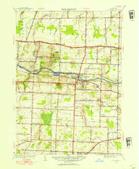 1952 Spencerport1953 Print · USGSMonroe County's canal and rail corridor is captured here in the early fifties, showing the evolution of towns along the historic Erie Canal. Researchers can trace the layout of Spencerport, locate Roberts Wesleyan College, and find family names near Maple Grove Cem.3 unique versions available
End of results
Showing maps 1-4 of 4
Top cities near Riga
- Rochester historical maps
- Greece historical maps
- North Greece historical maps
- Henrietta historical maps
- Brighton historical maps
- Gates historical maps
See more
Top neighborhoods of Riga
Frequently asked questions
- What are the different types of historical maps available for Riga?
- What is the oldest map of Riga?
- Where can I purchase historical maps of Riga for my home or office?
- Where can I download high-res historical maps of Riga?
- Are there historical topographic maps available for Riga?
- Is there historical aerial imagery available for Riga?
- Where are historical maps of Riga sourced from?