1900s (20th Century) Maps of North Hempstead, New York
Explore 30 historic maps of North Hempstead from the 1900s (20th Century). These maps offer a rare glimpse into what life looked like during the 1900s — showing old roads, neighborhoods, homes, and landmarks that have changed or disappeared over time.
Whether you're researching your family's past, planning a metal detecting trip, or studying how North Hempstead's landscape evolved across the 1900s, these high-resolution maps are a powerful tool for exploring the history of this region.
- Focus on a specific era: All maps on this page are from the 1900s, giving you a focused view of this time period.
- See what’s changed: Compare century-old streets, trails, and buildings to today's modern landscape using overlays and satellite layers.
- Research with precision: Use these maps for genealogy, historical research, land use analysis, or educational projects.
- View, download, or print: Maps are fully viewable online in high resolution, and can be downloaded or printed for your own records.
Start exploring North Hempstead's history through authentic maps from the 1900s. This is your window into the past.
North Hempstead, NY maps
(30)- 1900 Map of Harlem
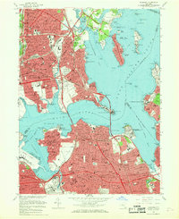
 1900 Harlem1900 Print · USGSUpper Manhattan and the surrounding boroughs are shown at a pivotal moment of growth before the mid-century building boom. Genealogists can trace family footprints through the streets of Yonkers Park or locate ancestors in the sprawling Woodlawn Cemetery.16 unique versions available
 - 1900 Map of Oyster Bay
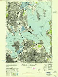
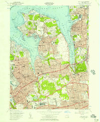
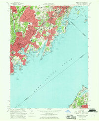
 1900 Oyster Bay1900 Print · USGSThe North Shore of Long Island is captured at the turn of the century as its maritime villages and sprawling estates began to transition into refined commuter suburbs. Genealogists can trace property and neighborhood development in Sea Cliff, Glen Cove, and Oyster Bay before the automobile era.15 unique versions available
 - 1903 Map of Hempstead
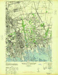
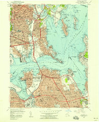
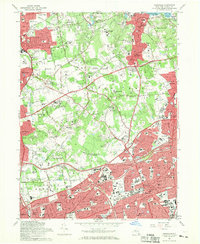
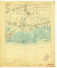 1903 Hempstead1903 Print · USGSSouthern Nassau County at the turn of the century shows a landscape transitioning from rural estates and marshlands to rail-connected villages. Genealogists can trace family footprints in Hempstead or Garden City and locate coastal landmarks like Christian Hook and the Camp Meeting Grounds.9 unique versions available
 - 1947 Map of Mamaroneck
 1947 Mamaroneck1947 Print · USGSCoastal Westchester and Nassau Counties are shown here just after the war as the region's grand estates and suburban centers flourished. Genealogists and historians can locate private landmarks like the J P Morgan property, Pratts Estate, and St Thomas Ch.
 - 1947 Map of Hicksville
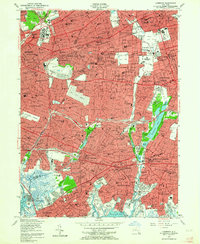
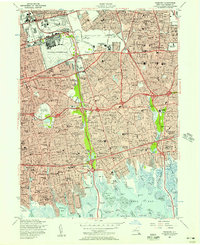
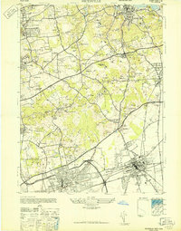 1947 Hicksville1947 Print · USGSMid-century Nassau County is captured here as the storied Gold Coast estates began to meet the expanding suburban reach of Hicksville and Syosset. Genealogists and historians can locate family-named lands like the Davison Estate or visit the T Roosevelt Grave at Young Memorial Cemetery.
 - 1947 Map of Sea Cliff
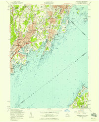
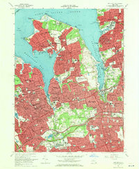
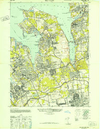 1947 Sea Cliff1947 Print · USGSThe Gold Coast of Nassau County is captured here in the late 1940s, showcasing a landscape of massive private estates and yacht clubs. Trace family-named landmarks like the Vanderbilt Estate or find historic aviation sites like the New York Seaplane Airport.
 - 1947 Map of Lynbrook
 1947 Lynbrook1947 Print · USGSNassau County and the Queens border are shown here in the late forties during a period of massive suburban growth. Genealogists and historians can trace rail-centered communities, family sites near Elmont Cem, and major landmarks like Belmont Park Race Track or the Curtiss Wright Airport.
 - 1947 Map of Flushing
 1947 Flushing1947 Print · USGSThe coastal transition of Queens and the Bronx is captured just after the war as parkways and airfields reshaped the shoreline. Researchers can locate military sites like Fort Totten or trace family roots at Flushing Cem and the Franciscan Poor Clares Monastery.2 unique versions available
 - 1947 Map of Freeport
 1947 Freeport1947 Print · USGSNassau County's south shore and aviation hubs are caught in detail just after the war. Local historians can trace the transition from marshland to suburbia through landmarks like Roosevelt Field, the Jones Beach Hotel, and the Meadow Brook Polo Field.
 - 1949 Map of New York, 1951 Print
 1949 New York1951 Print · USGSLong Island and its surrounding waters are documented here in the late 1940s, just as the postwar suburban boom began to transform the region. Genealogists and historians can trace the early layouts of Idlewild Airport, Mitchell Field, and the established routes of the Long Island RR.
 - 1954 Map of New York
 1954 New York1954 Print · USGSLong Island and the New York metropolitan area are shown during the height of post-war suburbanization. Genealogists and historians can trace the growth of Levittown, the infrastructure of the Long Island Rail Road, and landmarks like Mitchel Afb.2 unique versions available
 - 1954 Map of Lynbrook, 1957 Print
 1954 Lynbrook1957 Print · USGSWestern Nassau County and eastern Queens hum with post-war suburban energy at the height of the mid-century. Genealogists and local historians can trace the neighborhood structures of New Hyde Park and Lynbrook, or locate specific landmarks like the Cathedral of the Incarnation and Old Springfield Cem.2 unique versions available
 - 1954 Map of Hicksville, 1957 Print
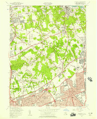 1954 Hicksville1957 Print · USGSMid-century Nassau County is captured here as the North Shore's estates meet the expanding residential tracts of the post-war era. Researchers can trace the legacy of the area through landmarks like the T Roosevelt Mem Grave and the Friends Mtg House.2 unique versions available
 - 1954 Map of Sea Cliff, 1957 Print
 1954 Sea Cliff1957 Print · USGSNassau County's prestigious North Shore is shown in the mid-fifties as historic estates and yacht clubs transitioned into a modern suburban landscape. Researchers can trace local landmarks like the Roslyn Air Force Station, St Ignatius Seminary, and the winding Long Island RR through Manhasset.2 unique versions available
 - 1955 Map of Flushing, 1957 Print
 1955 Flushing1957 Print · USGSThe northern reaches of Queens and the Bronx are captured during the mid-fifties era of rapid parkway and airport expansion. Genealogists and local historians can locate long-standing institutions like St Raymonds Cemetery, Fort Totten, and La Guardia Field.2 unique versions available
 - 1955 Map of Freeport, 1957 Print
 1955 Freeport1957 Print · USGSNassau County is seen during its peak post-war suburban transformation, where new housing tracts meet established coastal villages. Researchers can trace family roots through dozens of local institutions like Hofstra College, Greenfield Cemetery, and the historic Mitchell Air Force Base.
 - 1955 Map of Mamaroneck, 1958 Print
 1955 Mamaroneck1958 Print · USGSThe Westchester shoreline and Long Island Sound are captured here during a decade of suburban expansion and parkway development. Genealogists and historians can locate family landmarks from Greenwood Union Cemetery to the Webb Institute or the Execution Rocks Lighthouse.2 unique versions available
 - 1957 Map of New York, 1975 Print
 1957 New York1975 Print · USGSLong Island and the New York metropolitan area are shown in this mid-century survey during a period of massive suburban growth and industrial expansion. Researchers can trace the Long Island RR network and locate landmarks like Fort Tilden or the Brookhaven National Laboratory.
 - 1958 Map of New York
 1958 New York1958 Print · USGSLong Island at the height of its postwar expansion reveals a landscape of rapidly growing suburbs and critical military installations. Genealogists and historians can trace the early footprints of Levittown, the terminals of Idlewild Airport, and the grounds of Brookhaven National Laboratory.3 unique versions available
 - 1960 Map of New York, 1979 Print
 1960 New York1979 Print · USGSLong Island and the five boroughs are shown at a transformative moment mid-century as suburban expansion reshaped the landscape. Researchers can trace family roots through evolving neighborhoods from Rockville Centre to Sayville, or locate historic maritime landmarks like Eatons Neck and Montauk Point.2 unique versions available
 - 1966 Map of Flushing, 1968 Print
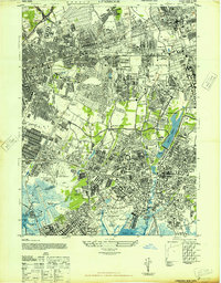
 1966 Flushing1968 Print · USGSQueens and the Bronx are shown at their mid-century peak, where dense neighborhood grids meet the massive interchanges of the modern expressway system. Genealogists and historians can locate family landmarks like St Raymonds Cemetery, early aviation sites at La Guardia Airport, and the newly built Shea Stadium.4 unique versions available
 - 1967 Map of Hicksville, 1969 Print
 1967 Hicksville1969 Print · USGSNassau County's landscape undergoes a mid-century transformation as suburban growth reaches northward from Hicksville toward the Oyster Bay Harbor. Researchers can locate Holy Rood Cemetery, the Roosevelt Grave, and dozens of local schools like City of Children Sch.3 unique versions available
 - 1967 Map of Mamaroneck, 1969 Print
 1967 Mamaroneck1969 Print · USGSCoastal Westchester County and northern Long Island meet across the sound in the late sixties. Genealogists and local historians can trace the estates and institutions of the era, from Haviland Cem to the Van Amringe Millpond and Dosoris Island.2 unique versions available
 - 1968 Map of Sea Cliff, 1970 Print
 1968 Sea Cliff1970 Print · USGSNassau County's North Shore is shown in its mid-century maturity, featuring the densely settled Gold Coast villages and deep harbors. Researchers can locate family landmarks like Nassau Knolls Cemetery, the Guggenheim Estate, and historic local schools such as North Shore High Sch.2 unique versions available
 - 1969 Map of New York
 1969 New York1969 Print · USGSLong Island and the New York harbor area are shown here during a peak era of suburban expansion and Cold War defense. Trace the growth of Levittown, the infrastructure of Idlewild NY International Airport, and the reach of the Long Island RR.
Showing maps 1-25 of 30
Top cities near North Hempstead
- New York historical maps
- Hempstead historical maps
- Oyster Bay historical maps
- Yonkers historical maps
- Huntington historical maps
- Stamford historical maps
See more
Top neighborhoods of North Hempstead
- Mineola historical maps
- Port Washington historical maps
- Westbury historical maps
- North New Hyde Park historical maps
- New Cassel historical maps
- Great Neck historical maps
See more
Frequently asked questions
- What are the different types of historical maps available for North Hempstead?
- What is the oldest map of North Hempstead?
- Where can I purchase historical maps of North Hempstead for my home or office?
- Where can I download high-res historical maps of North Hempstead?
- Are there historical topographic maps available for North Hempstead?
- Is there historical aerial imagery available for North Hempstead?
- Where are historical maps of North Hempstead sourced from?