Old Maps of New York County, New York for Genealogy
Trace your family roots with 81 historic maps of New York County. These high-res maps reveal old neighborhoods, homesites, landmarks, and streets — helping you uncover where your ancestors lived and how the area evolved over time.
- Explore historic neighborhoods: Identify where your relatives may have lived in the 1800s or 1900s.
- Compare maps over time: Trace the changes in streets, buildings, and landmarks for multi-generational research.
- Perfect for genealogy & ancestry research: Used by family historians and researchers to map out lineage and migration.
These maps are an incredible resource for exploring your personal connection to New York County's past.
New York County, NY maps
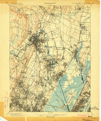
(81)- 1888 Map of Paterson
 1888 Paterson1888 Print · USGSNortheastern New Jersey in the late nineteenth century was a complex network of industrial canals and rising commuter towns. Genealogists and historians can trace the Morris Canal, the Jersey City Waterworks, and early rail lines through Hackensack and Paterson.
 - 1889 Map of Brooklyn
 1889 Brooklyn1889 Print · USGSBrooklyn and Queens are shown here in the late nineteenth century as urban grids began to overtake the old farm townships. Genealogists and historians can trace defunct rail lines and early settlements like Winfield Junction, Hollis, and Canarsie Landing.
 - 1891 Map of Brooklyn
 1891 Brooklyn1891 Print · USGSThe Brooklyn and Queens landscape of the early 1890s is captured here at a moment of intense rail-driven growth. Researchers can trace the original shoreline of Jamaica Bay and locate family history in the Navy Yard or at Evergreen Cemetery.
 - 1891 Map of Harlem
 1891 Harlem1891 Print · USGSUpper Manhattan and the Bronx met the burgeoning towns of Westchester and Bergen County in the late 1800s. Researchers can trace the path of the Croton Aqueduct, locate the historic site of Bulls Ferry, and explore the early rail-connected villages of Schraalenburgh and Pelhamville.
 - 1892 Map of Paterson
 1892 Paterson1892 Print · USGSNorthern New Jersey and the industrial core of Paterson are seen here in the late nineteenth century as rail and water infrastructure expanded. Trace the development of early utility systems like the Jersey City Waterworks or explore the rail lines of the Lodi Branch R.R. and West Shore Railroad.
 - 1897 Map of Harlem, 1956 Print
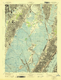
 1897 Harlem1956 Print · USGSUpper Manhattan and Westchester thrive at the end of the nineteenth century as rail lines and reservoirs reshape the landscape. Trace early neighborhoods and landmarks like Schraalenburg, Woodlawn Cemetery, and the Jerome Park Reservoir.4 unique versions available
 - 1897 Map of Brooklyn, 1959 Print
 1897 Brooklyn1959 Print · USGSBrooklyn and Queens are captured in the late nineteenth century as rural townships began their rapid transformation into a dense urban landscape. Genealogists can locate family plots in Greenwood Cemetery or trace early neighborhood origins in New Utrecht and Flatbush.3 unique versions available
 - 1898 Map of Harlem
 1898 Harlem1898 Print · USGSThe northern reaches of the city and its surrounding suburbs are shown in late-Victorian detail as rail lines expanded across the Hudson. Researchers can trace the early layouts of Woodlawn Cemetery, the site of Grants Tomb, and the fortifications at Fort Schuyler.
 - 1898 Map of Staten Island
 1898 Staten Island1898 Print · USGSGreater Staten Island and the industrial shores of New Jersey are captured during the peak of the Victorian maritime era. Genealogists can trace early neighborhood boundaries and landmarks like Moravian Cemetery, the Morris Canal, and the vanished industry of Linoleumville.
 - 1898 Map of Brooklyn
 1898 Brooklyn1898 Print · USGSBrooklyn and Queens at the close of the nineteenth century reveal a landscape of growing commuter suburbs and vast, untouched tidal marshes. Genealogists and historians can trace old property boundaries near Greenwood Cemetery or follow the early rail lines through Winfield Junction and Jamaica.
 - 1898 Map of Paterson
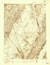
 1898 Paterson1898 Print · USGSNorthern New Jersey's industrial and rail corridors are captured here in the late nineteenth century, from the silk mills of Paterson to the Hackensack marshes. Genealogists can locate family sites near Laurel Grove Cemetery, the Morris Canal, and early villages like Wortendyke.
 - 1900 Map of Passaic
 1900 Passaic1900 Print · USGSNorthern New Jersey and the New York Harbor are captured here at the close of the nineteenth century, showing a landscape defined by rail, river, and coastal defense. Researchers can trace the original path of the Morris Canal, locate Seton Hall College, and explore the batteries at Fort Wadsworth.
 - 1900 Map of Paterson
 1900 Paterson1900 Print · USGSNortheastern New Jersey at the turn of the century shows a landscape defined by the Morris Canal and a dense network of early railroads. Researchers can trace ancestral roots through vanished rail stops and sites like Laurel Grove Cemetery, Wortendyke, and Sicomac.
 - 1900 Map of Staten Island
 1900 Staten Island1900 Print · USGSThe New York and New Jersey harbor comes alive in the late Victorian era, showing Staten Island when small villages and defensive forts still defined the coastline. Trace family roots and vanished landmarks through Fort Wadsworth, the Morris Canal, and historic settlements like Rossville or Tottenville.10 unique versions available
 - 1900 Map of Harlem
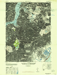
 1900 Harlem1900 Print · USGSUpper Manhattan and the surrounding boroughs are shown at a pivotal moment of growth before the mid-century building boom. Genealogists can trace family footprints through the streets of Yonkers Park or locate ancestors in the sprawling Woodlawn Cemetery.16 unique versions available
 - 1900 Map of Brooklyn
 1900 Brooklyn1900 Print · USGSBrooklyn and Queens are shown here at the turn of the century as the urban grid begins to overtake rural villages and coastal marshes. Genealogists can locate family plots in Greenwood Cemetery or Evergreen Cemetery and trace early transit routes like the Electric R.R. and Kings Highway.11 unique versions available
 - 1903 Map of Paterson
 1903 Paterson1903 Print · USGSNorthern New Jersey's transition from an industrial river valley to a dense rail-connected region is captured here just after the turn of the century. You can trace the path of the Morris Canal, locate the old Dundee Dam, or find early settlements like Peetzburg and Etna.8 unique versions available
 - 1905 Map of Passaic
 1905 Passaic1905 Print · USGSNorthern New Jersey and Staten Island appear here at a pivotal moment of early 20th-century growth and industrialization. Researchers can trace the development of transit hubs like Convent Sta. or locate legacy landmarks including Hillside Cemetery and the Moravian Cemetery.4 unique versions available
 - 1935 Map of Weehawken
 1935 Weehawken1935 Print · USGSBergen and Hudson counties in the mid-1930s show a dense grid of riverfront industry and rail lines interwoven with tidal marshes. Genealogists and historians can locate numerous cemeteries like Holy Cross Cem or trace institutional landmarks like the Hudson County Hospital.
 - 1940 Map of Weehawken
 1940 Weehawken1940 Print · USGSBergen and Hudson Counties are shown just before the wartime industrial boom, highlighting a landscape where massive rail yards met expansive tidal marshes. Researchers can trace ancestral roots through dozens of local landmarks like Flower Hill Cem, Bendix Airport, and the Hudson County Penitentiary.3 unique versions available
 - 1942 Map of Passaic
 1942 Passaic1942 Print · USGSNorthern New Jersey and New York harbor appear in detail at the start of the war, showing a landscape of burgeoning suburbs and vital industry. Trace family roots and local history across the Passaic River valley, from Paterson to the Watchung Mountains.
 - 1943 Map of Weehawken
 1943 Weehawken1943 Print · USGSNorthern New Jersey during the Second World War was a vital industrial hub of rail yards and river commerce. Researchers can trace ancestral roots through urban street grids and find landmarks like the Monastery, Bendix Airport, and Secaucus Yards.
 - 1944 Map of Newark, 1971 Print
 1944 Newark1971 Print · USGSThe industrial corridor from Philadelphia to New York was in a period of massive transition during the mid-forties. Genealogists and researchers can trace the rail lines of the Lehigh Valley RR, locate military installations like Picatinny Arsenal, and explore the early sprawl near Levittown.5 unique versions available
 - 1947 Map of Brooklyn
 1947 Brooklyn1947 Print · USGSMid-century Brooklyn and Queens are documented here in incredible detail just after the war years. Local historians can locate the iconic Ebbets Field, trace the rail lines through the New Lots Classification Yards, or find ancestral sites at Holy Cross Cemetery.
 - 1947 Map of Jersey City
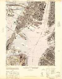 1947 Jersey City1947 Print · USGSThe harbor was a hive of industrial and maritime activity just after the war, featuring the intricate rail networks of the Lackawanna and Pennsylvania lines. Trace the early footprints of the Holland Vehicular Tunnels and landmarks like the Statue of Liberty.
Showing maps 1-25 of 81
Frequently asked questions
- What are the different types of historical maps available for New York County?
- What is the oldest map of New York County?
- Where can I purchase historical maps of New York County for my home or office?
- Where can I download high-res historical maps of New York County?
- Are there historical topographic maps available for New York County?
- Is there historical aerial imagery available for New York County?
- Where are historical maps of New York County sourced from?