1950s Maps of Utica, New York
Explore 5 historic maps of Utica from the 1950s. These maps offer a rare glimpse into what life looked like during the 1950s — showing old roads, neighborhoods, homes, and landmarks that have changed or disappeared over time.
Whether you're researching your family's past, planning a metal detecting trip, or studying how Utica's landscape evolved across the 1950s, these high-resolution maps are a powerful tool for exploring the history of this region.
- Focus on a specific era: All maps on this page are from the 1950s, giving you a focused view of this time period.
- See what’s changed: Compare century-old streets, trails, and buildings to today's modern landscape using overlays and satellite layers.
- Research with precision: Use these maps for genealogy, historical research, land use analysis, or educational projects.
- View, download, or print: Maps are fully viewable online in high resolution, and can be downloaded or printed for your own records.
Start exploring Utica's history through authentic maps from the 1950s. This is your window into the past.
Utica, NY maps
(5)- 1950 Map of Utica, 1951 Print
 1950 Utica1951 Print · USGSCentral New York in the post-war era showcases the industrial Mohawk Valley and the pristine Adirondack interior. Researchers can trace transportation networks like the New York Central Railroad and find early Cold War sites such as Griffiss Air Force Base.
 - 1955 Map of Utica West, 1957 Print
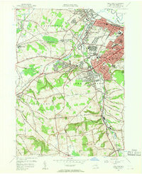 1955 Utica West1957 Print · USGSThe industrial corridor of the Mohawk Valley is captured here during the mid-fifties, showing the growth of Utica and New York Mills along the rail lines. Researchers can trace family roots through numerous sites like Holy Trinity Cem, St John Ch, and the Utica State Hospital grounds.2 unique versions available
 - 1955 Map of Utica East, 1957 Print
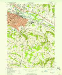 1955 Utica East1957 Print · USGSMid-century development meets the Mohawk Valley’s industrial roots in this survey of eastern Utica and the surrounding uplands. Researchers can trace the path of the Erie Canal, find local landmarks like the Masonic Home, and locate family sites near Frankfort Center and West Schuyler.2 unique versions available
 - 1955 Map of South Trenton, 1957 Print
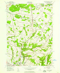 1955 South Trenton1957 Print · USGSThe northern outskirts of Utica meet the rising hills of Oneida County in the mid-fifties, showing a landscape defined by both water and wire. Researchers can trace historic family corridors along Stage Road, locate Salem Ch, or find the grounds of the Broadacres Sanatorium.2 unique versions available
 - 1957 Map of Utica
 1957 Utica1957 Print · USGSCentral New York and the Adirondack foothills are captured here in the mid-fifties, showing a landscape defined by the Mohawk River corridor and the growing highway system. Genealogists and researchers can trace the rail lines of the New York Central and locate communities from Lowville to Gloversville.
End of results
Showing maps 1-5 of 5
Top cities near Utica
- Rome historical maps
- New Hartford historical maps
- Whitestown historical maps
- German Flatts historical maps
- Kirkland historical maps
- Herkimer historical maps
See more
Top neighborhoods of Utica
Frequently asked questions
- What are the different types of historical maps available for Utica?
- What is the oldest map of Utica?
- Where can I purchase historical maps of Utica for my home or office?
- Where can I download high-res historical maps of Utica?
- Are there historical topographic maps available for Utica?
- Is there historical aerial imagery available for Utica?
- Where are historical maps of Utica sourced from?