1940s Maps of Vienna, New York
Explore 10 historic maps of Vienna from the 1940s. These maps offer a rare glimpse into what life looked like during the 1940s — showing old roads, neighborhoods, homes, and landmarks that have changed or disappeared over time.
Whether you're researching your family's past, planning a metal detecting trip, or studying how Vienna's landscape evolved across the 1940s, these high-resolution maps are a powerful tool for exploring the history of this region.
- Focus on a specific era: All maps on this page are from the 1940s, giving you a focused view of this time period.
- See what’s changed: Compare century-old streets, trails, and buildings to today's modern landscape using overlays and satellite layers.
- Research with precision: Use these maps for genealogy, historical research, land use analysis, or educational projects.
- View, download, or print: Maps are fully viewable online in high resolution, and can be downloaded or printed for your own records.
Start exploring Vienna's history through authentic maps from the 1940s. This is your window into the past.
Vienna, NY maps
(10)- 1941 Map of Cleveland
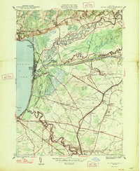
 1941 Cleveland1941 Print · USGSOneida Lake’s central waters and the surrounding shorelines are captured here in the early 1940s, highlighting a landscape of rail-connected villages and rural school districts. Genealogists can locate family landmarks like Smith Ridge Cem or trace the path of the New York Ontario and Western RR through Bernhard Bay.2 unique versions available
 - 1941 Map of Jewell
 1941 Jewell1941 Print · USGSOneida Lake shoreline communities in the early 1940s are documented here, showing a mix of established lakeside hamlets and inland farming hubs. Genealogists and local historians can locate early landmarks like Lakeport Chapel, West Church, and the rural Whitelaw Cem.
 - 1943 Map of Camden West
 1943 Camden West1943 Print · USGSThe rural landscapes of Oneida and Oswego counties are captured here in the mid-1940s, showing a world of small schoolhouses and family-named crossroads. Researchers can trace historic cemeteries like Pete Lynch Cem or locate vanished landmarks near Brockway Corners and Maple Flats.2 unique versions available
 - 1943 Map of Camden East
 1943 Camden East1943 Print · USGSOneida County at the height of the Second World War reveals a landscape of thriving rural hamlets and intricate river systems. Genealogists and historians can trace local families through many rural schoolhouses and cemeteries like St Johns Cem and the Old Protestant Cem.
 - 1943 Map of Lee Center
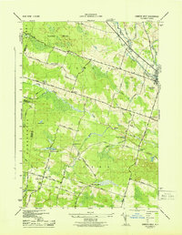
 1943 Lee Center1943 Print · USGSOneida County in the early 1940s reveals a landscape of small hamlets and rural school districts connected by the winding Fish Creek. Genealogists can trace family homesteads near Lee Center, Taberg, and numerous historic burials like Hall Cem and Link Cem.
 - 1944 Map of Cleveland
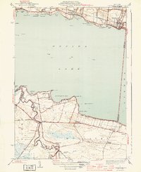 1944 Cleveland1944 Print · USGSOneida Lake's northern and southern shores are captured here during the mid-1940s, showing a landscape defined by the railroad and the canal. Genealogists can trace family roots through school locations like Bushnell Sch and early road networks including Bull Street and Lagrange Road.2 unique versions available
 - 1944 Map of Jewell
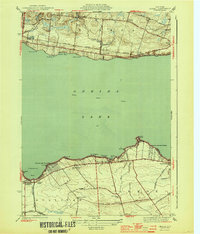 1944 Jewell1944 Print · USGSOneida Lake and its surrounding hamlets are captured here during the mid-forties, highlighting the vital lakefront economies of both the north and south shores. Genealogists and local historians can trace family locations near Jewell, Lakeport, or the Whitelaw Cem.2 unique versions available
 - 1946 Map of Oneida, 1952 Print
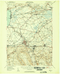 1946 Oneida1952 Print · USGSIn the mid-1940s, the corridor between Oneida Lake and the Erie Canal was a landscape of manufacturing towns and lakeside resorts. Genealogists and historians can trace the foundations of local communities through named landmarks like Oneida Castle, Irish Ridge Ch, and the Indian Sch.3 unique versions available
 - 1947 Map of Sylvan Beach
 1947 Sylvan Beach1947 Print · USGSThe eastern shores of Oneida Lake in the late 1940s showcase a landscape of canal towns and lakefront resorts. Genealogists can trace family names through landmarks like Irish Ridge Ch, Grove Cem, and numerous schoolhouses including Maple Grove Sch.
 - 1948 Map of Verona
 1948 Verona1948 Print · USGSOneida County in the late 1940s reveals a landscape defined by the transition between old and new transit corridors. You can trace family homesteads near Stacy Basin, locate local schools like Sand Hill Sch, and follow the path of the Erie Canal (Abandoned).
End of results
Showing maps 1-10 of 10
Top cities near Vienna
- Manlius historical maps
- Rome historical maps
- Cicero historical maps
- Sullivan historical maps
- Oneida historical maps
- Lenox historical maps
See more
Top neighborhoods of Vienna
- Maple Flats historical maps
- Dibbletown historical maps
- Edgewater Beach historical maps
- Pine historical maps
- Fish Creek Landing historical maps
- Elpis historical maps
See more
Frequently asked questions
- What are the different types of historical maps available for Vienna?
- What is the oldest map of Vienna?
- Where can I purchase historical maps of Vienna for my home or office?
- Where can I download high-res historical maps of Vienna?
- Are there historical topographic maps available for Vienna?
- Is there historical aerial imagery available for Vienna?
- Where are historical maps of Vienna sourced from?