1940s Maps of Dix, Westmoreland
Explore 2 historic maps of Dix from the 1940s. These maps offer a rare glimpse into what life looked like during the 1940s — showing old roads, neighborhoods, homes, and landmarks that have changed or disappeared over time.
Whether you're researching your family's past, planning a metal detecting trip, or studying how Dix's landscape evolved across the 1940s, these high-resolution maps are a powerful tool for exploring the history of this region.
- Focus on a specific era: All maps on this page are from the 1940s, giving you a focused view of this time period.
- See what’s changed: Compare century-old streets, trails, and buildings to today's modern landscape using overlays and satellite layers.
- Research with precision: Use these maps for genealogy, historical research, land use analysis, or educational projects.
- View, download, or print: Maps are fully viewable online in high resolution, and can be downloaded or printed for your own records.
Start exploring Dix's history through authentic maps from the 1940s. This is your window into the past.
Dix, Westmoreland maps
(2)- 1947 Map of Rome, 1952 Print
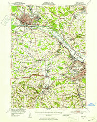 1947 Rome1952 Print · USGSMid-century Oneida County is captured here during the height of its industrial and military significance. Researchers can trace the paths of the Old Erie Canal, locate family roots near St Johns Cem, or study the grounds of Hamilton College.3 unique versions available
 - 1949 Map of Rome
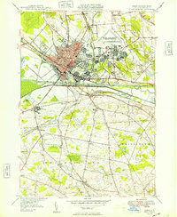 1949 Rome1949 Print · USGSRome was a bustling transportation and military hub in the late 1940s, where the Mohawk River valley met the industrial age. Local historians can trace the massive Rome Air Depot, the path of the BARGE CANAL, and long-standing family locales like Wright Settlement.
End of results
Showing maps 1-2 of 2
Top cities near Dix
- Utica historical maps
- Rome historical maps
- New Hartford historical maps
- Whitestown historical maps
- Oneida historical maps
- Kirkland historical maps
See more
Frequently asked questions
- What are the different types of historical maps available for Dix?
- What is the oldest map of Dix?
- Where can I purchase historical maps of Dix for my home or office?
- Where can I download high-res historical maps of Dix?
- Are there historical topographic maps available for Dix?
- Is there historical aerial imagery available for Dix?
- Where are historical maps of Dix sourced from?