Old Maps of Onondaga County, New York
Explore 203 old maps of Onondaga County, spanning from 1895 to today. These high-resolution historic maps reveal how streets, neighborhoods, landmarks, and natural features evolved over time — perfect for genealogy, metal detecting, research, and local history exploration.
What you can do with these maps:
- See how Onondaga County changed over time: Compare historical maps to modern-day views to trace roads, homesites, rail lines & more.
- View detailed metadata: Each map includes creators, publishers, year, scale, and archive source.
- Overlay maps with satellite & LiDAR: Visualize the past alongside modern tools to explore terrain & human change.
- Trusted historical sources: Maps sourced from the USGS, Library of Congress, and other archives.
- Access maps your way: View online, download high-res files, or order prints for personal or research use.
Start exploring old maps of Onondaga County to uncover forgotten places, hidden landmarks, and the deep history beneath your feet.
Onondaga County, NY maps
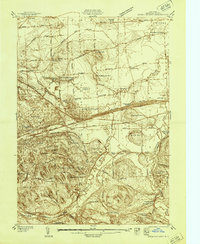
(203)- 1895 Map of Chittenango
 1895 Chittenango1895 Print · USGSMadison County and the southern shores of Oneida Lake are shown here at the height of the canal and rail era. Researchers can trace the path of the Erie Canal through Chittenango and Canastota or locate vanished sites like Fyler Settlement.
 - 1895 Map of Syracuse
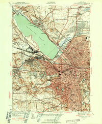
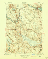
 1895 Syracuse1895 Print · USGSSyracuse and the surrounding canal country are captured here in the late nineteenth century as the region thrived on salt production and rail traffic. Trace the vanished industrial Salt Sheds, the historic Erie Canal, and landmarks like the State Fair Grounds.
 - 1897 Map of Cazenovia, 1953 Print
 1897 Cazenovia1953 Print · USGSMadison and Onondaga Counties are shown here just before the turn of the century, revealing a landscape defined by emerging rail lines and historic hamlets. Researchers can trace family roots through the Cowles Settlement, locate the Constine Bridge, or follow the Lehigh Valley R. R. through Delphi Station.
 - 1898 Map of Syracuse
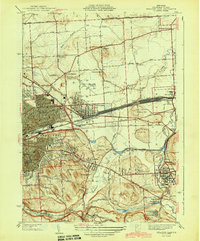
 1898 Syracuse1898 Print · USGSSyracuse was a burgeoning railroad and canal junction at the end of the nineteenth century, surrounded by thriving villages and salt works. Genealogists and historians can trace family-named sites and vanished industrial works near the Salt Sheds, Cicero Swamp, and Fayetteville.10 unique versions available
 - 1898 Map of Chittenango
 1898 Chittenango1898 Print · USGSThe northern shore of Oneida Lake and the bustling Erie Canal corridor are captured here during the peak of New York's rail expansion. Researchers can trace the original canal path through Chittenango or locate vanished stops along the West Shore R. R. and Elmira and Cortland Br.
 - 1899 Map of Skaneateles
 1899 Skaneateles1899 Print · USGSThe Finger Lakes at the end of the nineteenth century reveal a landscape of lakeside steamboat landings and bustling mill towns. Follow the Steamboat Route from Skaneateles to Glen Haven, or trace the rural roads connecting Marysville, Borodino, and Marcellus.
 - 1899 Map of Cazenovia
 1899 Cazenovia1899 Print · USGSMadison and Onondaga Counties are shown here in the late nineteenth century, a landscape defined by emerging lakeside villages and vital railroad junctions. Genealogists can trace early homesteads and hamlets like Cowles Settlement, Quaker Settlement, and Sheds Corners.7 unique versions available
 - 1900 Map of Baldwinsville
 1900 Baldwinsville1900 Print · USGSOnondaga and Oswego counties are seen here at the close of the nineteenth century, when the Erie Canal still drove local commerce. Genealogists can trace family roots through canal towns like Jordan and river hubs like Baldwinsville and Phoenix.9 unique versions available
 - 1900 Map of Tully
 1900 Tully1900 Print · USGSIn the hills south of Syracuse during the late 1890s, this area supported a network of dairy farms and rail-dependent hamlets. Genealogists can locate long-lost rural communities like Maple Grove (Case P.O.), the Onondaga Indian Reservation, and the resort grounds at Assembly Park.9 unique versions available
 - 1902 Map of Skaneateles
 1902 Skaneateles1902 Print · USGSOnondaga and Cayuga counties come alive in the Victorian era as a network of steamboats and short-line railroads connects lakeside hamlets. Trace ancestral roots and old transport routes through Mottville, the Skaneateles RR, and remote landings like Gregory Ldg.9 unique versions available
 - 1902 Map of Chittenango
 1902 Chittenango1902 Print · USGSMadison and Onondaga Counties are shown at a peak of rail and canal activity in the early 1900s. Genealogists and historians can trace the path of the Erie Canal through Canastota or locate smaller locales like Fyler Settlement and Quality Hill.7 unique versions available
 - 1905 Map of Mexico
 1905 Mexico1905 Print · USGSOswego County at the turn of the century shows a landscape of busy crossroads and emerging rail junctions. Genealogists can trace family footprints through numerous named settlements like Colosse, Howardville, and Union Settlement or locate old industrial sites like Carleys Mills.6 unique versions available
 - 1938 Map of Syracuse East
 1938 Syracuse East1938 Print · USGSOnondaga County in the late 1930s shows a landscape of rail yards and growing suburban hamlets. Researchers can trace the industrial footprint of the New York Central Yards or locate local landmarks like the Orphans Home and St Marys Cemetery.2 unique versions available
 - 1939 Map of Syracuse West
 1939 Syracuse West1939 Print · USGSSyracuse and its surrounding townships show the height of the pre-war industrial era as the city expands toward the shores of Onondaga Lake. Genealogists and historians can trace the foundations of the community through the Erie Canal (Abandoned), the Salt Museum, and Syracuse University.3 unique versions available
 - 1940 Map of Brewerton
 1940 Brewerton1940 Print · USGSThe northern reaches of Onondaga County are captured here just before the war, centered on the historic Oneida River and canal systems. Researchers can trace the era's rural infrastructure through Woodard Sta, the Peat Swamp, and old landmarks like Morgan Ch.
 - 1940 Map of Cicero, 1957 Print
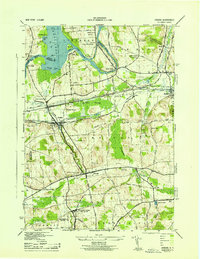
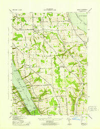
 1940 Cicero1957 Print · USGSOneida Lake’s southern shoreline was still largely rural and agricultural in the years before the war. Genealogists and local historians can trace family-named landmarks and early district schools like Van Anthrup Sch and the Cobblestone Sch.
 - 1941 Map of Cleveland
 1941 Cleveland1941 Print · USGSOneida Lake’s central waters and the surrounding shorelines are captured here in the early 1940s, highlighting a landscape of rail-connected villages and rural school districts. Genealogists can locate family landmarks like Smith Ridge Cem or trace the path of the New York Ontario and Western RR through Bernhard Bay.2 unique versions available
 - 1942 Map of Oran, 1957 Print
 1942 Oran1957 Print · USGSUpper Onondaga County during the early 1940s is mapped here with a focus on its steep ravines and rural school districts. Genealogists and hikers can trace old property boundaries near Delphi Falls, locate the Indian Hill Memorial, or find family plots like Sharp Cem.
 - 1943 Map of Syracuse East
 1943 Syracuse East1943 Print · USGSEastern Onondaga County during the mid-forties shows the industrial height of the rail and canal era. Genealogists and researchers can trace local landmarks like the Orphans Home, St Marys Cemetery, and the freight Yards at Minoa.2 unique versions available
 - 1943 Map of South Onondaga
 1943 South Onondaga1943 Print · USGSOnondaga County is captured during the mid-forties as Syracuse expands southward toward the ancestral lands of the Onondaga Indian Reservation. Genealogists and local historians can locate old district schools, numerous family cemeteries like Cedarvale Cem, and rural crossroads such as Lords Corners and Griffins Corners.
 - 1943 Map of Jordan
 1943 Jordan1943 Print · USGSJordan and Elbridge are centers of industry and transit during the mid-forties, where the old canal system meets the modern rail era. Trace the path of the ERIE CANAL, locate family roots at MAPLE GROVE CEM, or find old schoolhouses like School No 11 and School No 12.
 - 1943 Map of Lysander
 1943 Lysander1943 Print · USGSThe Seneca River valley in the early 1940s is shown here as a landscape of thriving rural hamlets and extensive canal infrastructure. Trace the network of old schoolhouses and cemeteries from Lysander to Plainville, or locate the family lands at Baird Corners.
 - 1943 Map of Brewerton
 1943 Brewerton1943 Print · USGSDuring the early 1940s, the rural landscape between Oneida Lake and North Syracuse was a network of small hamlets and water-based transit. Genealogists can trace family footprints at Dutch Settlement, find old schoolhouses like Baker Sch, or locate the Pine Plains Cem.2 unique versions available
 - 1943 Map of Spafford
 1943 Spafford1943 Print · USGSThe steep shorelines of Skaneateles and Otisco Lakes appear here during the mid-1940s. Genealogists and local historians can trace family locations through numerous named cemeteries like Kelloggsville Cem and schools such as School No 7.
 - 1943 Map of Owasco
 1943 Owasco1943 Print · USGSThe Finger Lakes uplands between Owasco Lake and Skaneateles Lake are captured here during the mid-century. Researchers can trace numerous family-named landmarks and rural burial grounds like Owasco Rural Cem, Valentine Corners, and Frozen Ocean.2 unique versions available
Showing maps 1-25 of 203
Top cities of Onondaga County
- Syracuse historical maps
- Clay historical maps
- Manlius historical maps
- Salina historical maps
- Cicero historical maps
- De Witt historical maps
See more
Frequently asked questions
- What are the different types of historical maps available for Onondaga County?
- What is the oldest map of Onondaga County?
- Where can I purchase historical maps of Onondaga County for my home or office?
- Where can I download high-res historical maps of Onondaga County?
- Are there historical topographic maps available for Onondaga County?
- Is there historical aerial imagery available for Onondaga County?
- Where are historical maps of Onondaga County sourced from?