
Loading...
Loading map...1895 Map of Chittenango
USGS Topo · Published 1895About this map
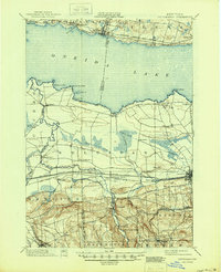
Oneida Lake dominates the northern landscape of this 1890s survey, its southern shoreline dotted with early points of interest like Shackelton Point and Lewis Point. The central portion of the map reveals the critical late-19th-century transportation corridor where the Erie Canal runs parallel to the West Shore R. R. and the New York Central and Hudson River R. R.. This infrastructure supported thriving local hubs such as Chittenango and Canastota.
Find a feature on this map
67 named features on this map. Tap any name to fly to it.
Don’t see what you’re looking for? This feature index may not catch every label — zoom into the map to look around manually.
Map Details
Date Portrayed1895
Date Published1895
PublisherU.S. Geological Survey
Map TypeTopographic
Scale1:62,500
Physical Dimensions16.6 x 20.2 inches
Editions of this 1895 Chittenango Map
This is the sole edition of this map. No revisions or reprints were ever made.
Historical Maps of Manlius Through Time
3 maps found

Featured Locations
Source Details
SourceU.S. Geological Survey
CopyrightPublic Domain