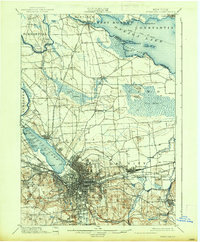
1895 Map of Syracuse
USGS Topo · Published 1895About this map
The industrial and transport hub of Syracuse anchors this late-19th-century survey, revealing a landscape defined by the convergence of the Erie Canal and the Oswego Canal. North of the city, the extensive Salt Sheds along the shores of Onondaga Lake speak to the region's historic salt industry, while the State Fair Grounds occupy a prominent position to the west. The map captures the dense network of competing rail lines, including the West Shore R. R. and the N. Y. C. and H. R. R. R., which fueled the city's growth.
Find a feature on this map
95 named features on this map. Tap any name to fly to it.
Don’t see what you’re looking for? This feature index may not catch every label — zoom into the map to look around manually.
Map Details
Editions of this 1895 Syracuse Map
This is the sole edition of this map. No revisions or reprints were ever made.
Historical Maps of Syracuse Through Time
3 maps found