
1895 Map of Oneida
USGS Topo · Published 1895About this map
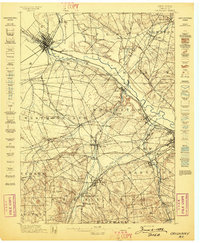
The Erie Canal and its associated waterways dominate this late-nineteenth-century landscape, showcasing a complex regional transport network before the full dominance of the automobile. The map reveals three distinct generations of canal infrastructure, including the Old Oneida Lake Canal and the New Oneida Lake Canal (Abandoned), illustrating the rapid evolution of engineering and commerce in central New York. These artificial waterways intersect with natural drainages like Wood Creek and Fish Creek, which flow toward the eastern shore of Oneida Lake.
Find a feature on this map
78 named features on this map. Tap any name to fly to it.
Don’t see what you’re looking for? This feature index may not catch every label — zoom into the map to look around manually.
Map Details
Editions of this 1895 Oneida Map
This is the sole edition of this map. No revisions or reprints were ever made.
Other maps of this area

1895 · Chittenango
USGS Topo · 1:62,500

1895 · Oriskany
USGS Topo · 1:62,500

1897 · Cazenovia
USGS Topo · 1:62,500

1898 · Oneida
USGS Topo · 1:62,500

1898 · Chittenango
USGS Topo · 1:62,500
1898 · Oriskany
USGS Topo · 1:62,500

1899 · Cazenovia
USGS Topo · 1:62,500

1902 · Chittenango
USGS Topo · 1:62,500
1902 · Morrisville
USGS Topo · 1:62,500

1902 · Oneida
USGS Topo · 1:62,500