Old Maps of East Cobleskill, Cobleskill
Explore 15 old maps of East Cobleskill, spanning from 1898 to today. These high-resolution historic maps reveal how streets, neighborhoods, landmarks, and natural features evolved over time — perfect for genealogy, metal detecting, research, and local history exploration.
What you can do with these maps:
- See how East Cobleskill changed over time: Compare historical maps to modern-day views to trace roads, homesites, rail lines & more.
- View detailed metadata: Each map includes creators, publishers, year, scale, and archive source.
- Overlay maps with satellite & LiDAR: Visualize the past alongside modern tools to explore terrain & human change.
- Trusted historical sources: Maps sourced from the USGS, Library of Congress, and other archives.
- Access maps your way: View online, download high-res files, or order prints for personal or research use.
Start exploring old maps of East Cobleskill to uncover forgotten places, hidden landmarks, and the deep history beneath your feet.
East Cobleskill, Cobleskill maps
(15)- 1898 Map of Schoharie, 1963 Print
 1898 Schoharie1963 Print · USGSSchoharie County in the late nineteenth century was a landscape of vital river valleys and developing rail lines. Local historians can trace the paths of the Delaware and Hudson RR or locate old hamlets like Breakabeen and Fultonham.
 - 1900 Map of Schoharie
 1900 Schoharie1900 Print · USGSSchoharie County at the turn of the century shows a landscape defined by the winding Schoharie Creek and vital rail connections. Genealogists can trace family roots through specific locations like Howe Cave, Mineral Springs, and the various stops along the Middleburg and Schoharie RR.8 unique versions available
 - 1943 Map of Cobleskill, 1954 Print
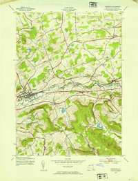 1943 Cobleskill1954 Print · USGSSchoharie County's rugged valley and rail corridor are captured here during the 1940s, anchored by the town of Cobleskill. Genealogists and historians can locate specific sites like the State Agricultural School, Howe Caverns, and the Lawyer Cem.4 unique versions available
 - 1945 Map of Cobleskill
 1945 Cobleskill1945 Print · USGSSchoharie County in the mid-1940s is defined by its railroad valley and early tourist attractions. Researchers can trace family plots like Guernsey Cem, find the original State Agricultural School site, and locate Howe Caverns and Secret Caverns.
 - 1948 Map of Binghamton, 1980 Print
 1948 Binghamton1980 Print · USGSCentral New York and the Southern Tier thrive in the late 1940s as a hub of rail traffic and mountain industry. Researchers can trace historic transit lines like the Erie Railroad through Binghamton or find old valley settlements near Oneonta and Delhi.
 - 1950 Map of Binghamton
 1950 Binghamton1950 Print · USGSBinghamton and the surrounding Southern Tier are shown in the mid-century era, highlighting the intricate rail and river networks that drove local industry. Researchers can trace the path of the Erie Railroad and locate landmarks from Otsego Lake to Sidney Mountain.2 unique versions available
 - 1958 Map of Binghamton
 1958 Binghamton1958 Print · USGSCentral New York in the late fifties was a network of manufacturing cities and river valleys connected by vital rail lines. Genealogists and historians can trace family roots in Oneonta, Norwich, and Cooperstown or locate long-standing farms along Schoharie Creek.
 - 1963 Map of Binghamton
 1963 Binghamton1963 Print · USGSThe Southern Tier and Catskill peaks are shown in the early sixties as new reservoirs reshaped the valleys. Trace historic rail corridors like the Erie Lackawanna RR and explore lakeside settlements such as Cooperstown and Oneonta.
 - 1985 Map of Amsterdam, 1986 Print
 1985 Amsterdam1986 Print · USGSUpstate New York in the mid-1980s reveals a landscape defined by historic river valleys and expanding interstate corridors. Researchers can trace family sites near Stone Arabia Cemetery or explore the civic centers of Amsterdam and Cooperstown near Otsego Lake.2 unique versions available
 - 1996 Map of Cobleskill, 2000 Print
 1996 Cobleskill2000 Print · USGSSchoharie County's valley floor and ridge-top hamlets are captured here during the late nineties. Genealogists and hikers can trace family burial plots like Slingerland Cem or explore the geography of Howe Caverns and Mineral Springs.
 - 2010 Map of Cobleskill, 2010 Print
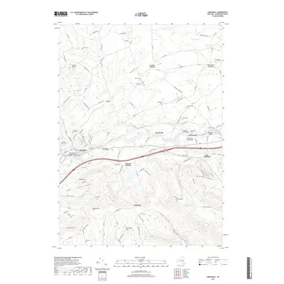
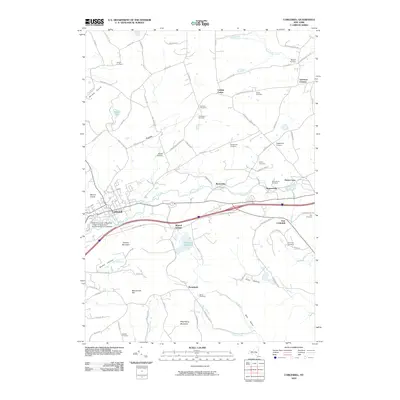 2010 Cobleskill2010 Print · USGSCovers East Cobleskill, including Cobleskill, Cobleskill, and other nearby areas
 - 2013 Map of Cobleskill, 2013 Print
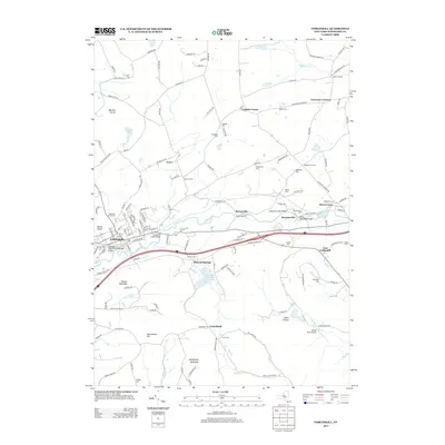 2013 Cobleskill2013 Print · USGSCovers East Cobleskill, including Cobleskill, Cobleskill, and other nearby areas
 - 2016 Map of Cobleskill, 2016 Print
 2016 Cobleskill2016 Print · USGSCovers East Cobleskill, including Cobleskill, Cobleskill, and other nearby areas
 - 2019 Map of Cobleskill, 2019 Print
 2019 Cobleskill2019 Print · USGSCovers East Cobleskill, including Cobleskill, Cobleskill, and other nearby areas
 - 2023 Map of Cobleskill, 2023 Print
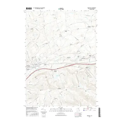
 2023 Cobleskill2023 Print · USGSSchoharie County's valley floor and ridge lines are meticulously detailed here, showing the development of Cobleskill and its surrounding hamlets. Genealogists and historians can trace dozens of family cemeteries like Lawyer Cem and Shultas Cem tucked between landmarks like Petersburg Mountain.
End of results
Showing maps 1-15 of 15
Top cities near East Cobleskill
- Cobleskill historical maps
- Duanesburg historical maps
- Amsterdam historical maps
- Cobleskill historical maps
- Minden historical maps
- Canajoharie historical maps
See more
Frequently asked questions
- What are the different types of historical maps available for East Cobleskill?
- What is the oldest map of East Cobleskill?
- Where can I purchase historical maps of East Cobleskill for my home or office?
- Where can I download high-res historical maps of East Cobleskill?
- Are there historical topographic maps available for East Cobleskill?
- Is there historical aerial imagery available for East Cobleskill?
- Where are historical maps of East Cobleskill sourced from?