1950s Maps of Hornby, New York
Explore 7 historic maps of Hornby from the 1950s. These maps offer a rare glimpse into what life looked like during the 1950s — showing old roads, neighborhoods, homes, and landmarks that have changed or disappeared over time.
Whether you're researching your family's past, planning a metal detecting trip, or studying how Hornby's landscape evolved across the 1950s, these high-resolution maps are a powerful tool for exploring the history of this region.
- Focus on a specific era: All maps on this page are from the 1950s, giving you a focused view of this time period.
- See what’s changed: Compare century-old streets, trails, and buildings to today's modern landscape using overlays and satellite layers.
- Research with precision: Use these maps for genealogy, historical research, land use analysis, or educational projects.
- View, download, or print: Maps are fully viewable online in high resolution, and can be downloaded or printed for your own records.
Start exploring Hornby's history through authentic maps from the 1950s. This is your window into the past.
Hornby, NY maps
(7)- 1950 Map of Elmira
 1950 Elmira1950 Print · USGSThe Finger Lakes region thrived in the late 1940s as a hub of industry and transport. Trace family roots and vanished landmarks near Seneca Lake or explore the rail lines of the Erie RR and the sprawling Seneca Ordnance Depot.2 unique versions available
 - 1953 Map of Bradford, 1955 Print
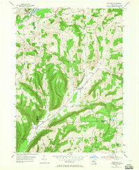 1953 Bradford1955 Print · USGSSchuyler and Steuben Counties are captured here in the early fifties, showing a rural landscape of valley farms and upland forests. Genealogists can trace family names through numerous burial sites like Old Sugar Hill Cem and Maltby Cem, or locate local landmarks like the Star District Sch.3 unique versions available
 - 1953 Map of Beaver Dams, 1955 Print
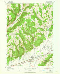
 1953 Beaver Dams1955 Print · USGSSchuyler and Chemung counties are seen here in the early 1950s, centered on the railroad corridor and rural hamlets. Researchers can trace family history through local landmarks like Savory Cem, Catlin Center Sch, and the New York Central line at Beaver Dams.3 unique versions available
 - 1953 Map of Corning, 1955 Print
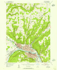 1953 Corning1955 Print · USGSCorning and the Chemung River valley are captured in the early fifties at the height of their industrial and rail importance. Researchers can trace the layout of historic wards and school districts, locating sites like Painted Post, Gang Mills, and the County Courthouse.2 unique versions available
 - 1953 Map of Big Flats, 1955 Print
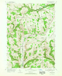
 1953 Big Flats1955 Print · USGSBig Flats and the Chemung River valley are shown in detail during the early fifties, a time when rail travel still dominated the local corridor. Researchers can pinpoint long-standing landmarks like the Rural Home Cem, Fisherville, and several neighborhood schools including Farr Sch.2 unique versions available
 - 1953 Map of Elmira, 1961 Print
 1953 Elmira1961 Print · USGSChemung County and the Pennsylvania borderlands are captured here in the early fifties, showing the industrial pulse of the river valley. Trace family roots through numerous district schools like Quackenbush Sch and burial grounds such as Woodlawn Cem.2 unique versions available
 - 1958 Map of Elmira
 1958 Elmira1958 Print · USGSThe New York Finger Lakes during the late fifties reveal a complex landscape of glacial geology and industrial growth. Researchers can trace historic transport corridors like the Erie Canal and Erie RR, or locate institutional landmarks like Cornell University.2 unique versions available
End of results
Showing maps 1-7 of 7
Top cities near Hornby
- Elmira historical maps
- Horseheads historical maps
- Bath historical maps
- Corning historical maps
- Southport historical maps
- Erwin historical maps
See more
Top neighborhoods of Hornby
Frequently asked questions
- What are the different types of historical maps available for Hornby?
- What is the oldest map of Hornby?
- Where can I purchase historical maps of Hornby for my home or office?
- Where can I download high-res historical maps of Hornby?
- Are there historical topographic maps available for Hornby?
- Is there historical aerial imagery available for Hornby?
- Where are historical maps of Hornby sourced from?