1940s Maps of Wayland, New York
Explore 3 historic maps of Wayland from the 1940s. These maps offer a rare glimpse into what life looked like during the 1940s — showing old roads, neighborhoods, homes, and landmarks that have changed or disappeared over time.
Whether you're researching your family's past, planning a metal detecting trip, or studying how Wayland's landscape evolved across the 1940s, these high-resolution maps are a powerful tool for exploring the history of this region.
- Focus on a specific era: All maps on this page are from the 1940s, giving you a focused view of this time period.
- See what’s changed: Compare century-old streets, trails, and buildings to today's modern landscape using overlays and satellite layers.
- Research with precision: Use these maps for genealogy, historical research, land use analysis, or educational projects.
- View, download, or print: Maps are fully viewable online in high resolution, and can be downloaded or printed for your own records.
Start exploring Wayland's history through authentic maps from the 1940s. This is your window into the past.
Wayland, NY maps
(3)- 1942 Map of Wayland
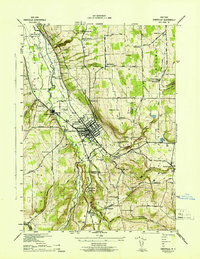
 1942 Wayland1942 Print · USGSThe intersection of the Erie and Delaware Lackawanna railroads in the early 1940s highlights this busy valley corridor. Genealogists can trace family roots through a dozen numbered schools and named cemeteries like Ashley Cem and St Josephs Cem.
 - 1942 Map of Dansville
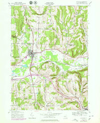
 1942 Dansville1942 Print · USGSDansville and the surrounding Livingston County uplands are documented here during the early years of the Second World War. Researchers can trace the path of the Delaware Lackawanna and Western RR or locate family sites near Stony Brook State Park and Holy Cross Ch.5 unique versions available
 - 1943 Map of Wayland, 1979 Print
 1943 Wayland1979 Print · USGSSteuben County was a landscape of small valley settlements and upland school districts at the height of the mid-century. Genealogists can trace family footprints through numerous sites like St Josephs Cem, Patchinville, and over a dozen rural schoolhouses.
End of results
Showing maps 1-3 of 3
Top cities near Wayland
- Bath historical maps
- Hornell historical maps
- North Dansville historical maps
- Dansville historical maps
- Hornellsville historical maps
- Richmond historical maps
See more
Top neighborhoods of Wayland
Frequently asked questions
- What are the different types of historical maps available for Wayland?
- What is the oldest map of Wayland?
- Where can I purchase historical maps of Wayland for my home or office?
- Where can I download high-res historical maps of Wayland?
- Are there historical topographic maps available for Wayland?
- Is there historical aerial imagery available for Wayland?
- Where are historical maps of Wayland sourced from?