1950s Maps of Dryden, New York
Explore 4 historic maps of Dryden from the 1950s. These maps offer a rare glimpse into what life looked like during the 1950s — showing old roads, neighborhoods, homes, and landmarks that have changed or disappeared over time.
Whether you're researching your family's past, planning a metal detecting trip, or studying how Dryden's landscape evolved across the 1950s, these high-resolution maps are a powerful tool for exploring the history of this region.
- Focus on a specific era: All maps on this page are from the 1950s, giving you a focused view of this time period.
- See what’s changed: Compare century-old streets, trails, and buildings to today's modern landscape using overlays and satellite layers.
- Research with precision: Use these maps for genealogy, historical research, land use analysis, or educational projects.
- View, download, or print: Maps are fully viewable online in high resolution, and can be downloaded or printed for your own records.
Start exploring Dryden's history through authentic maps from the 1950s. This is your window into the past.
Dryden, NY maps
(4)- 1950 Map of Elmira
 1950 Elmira1950 Print · USGSThe Finger Lakes region thrived in the late 1940s as a hub of industry and transport. Trace family roots and vanished landmarks near Seneca Lake or explore the rail lines of the Erie RR and the sprawling Seneca Ordnance Depot.2 unique versions available
 - 1951 Map of Ithaca East
 1951 Ithaca East1951 Print · USGSIthaca and the surrounding Tompkins County highlands are documented here during the early fifties, showing the university campus and its neighboring hamlets. Genealogists can trace family names at East Lawn Cemetery or follow the rail lines of the Lehigh Valley.
 - 1951 Map of Dryden
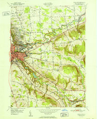
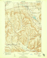 1951 Dryden1951 Print · USGSTompkins County hills and valleys are captured here in the early fifties, showing the area as a vital rail and road junction. Researchers can trace family roots through the Dutch Reformed Cem and follow the old Catskill Turnpike through Slaterville Springs.2 unique versions available
 - 1958 Map of Elmira
 1958 Elmira1958 Print · USGSThe New York Finger Lakes during the late fifties reveal a complex landscape of glacial geology and industrial growth. Researchers can trace historic transport corridors like the Erie Canal and Erie RR, or locate institutional landmarks like Cornell University.2 unique versions available
End of results
Showing maps 1-4 of 4
Top cities near Dryden
- Ithaca historical maps
- Ithaca historical maps
- Cortland historical maps
- Lansing historical maps
- Cortlandville historical maps
- Homer historical maps
See more
Top neighborhoods of Dryden
- Etna historical maps
- Ellis historical maps
- Hibbards Corner historical maps
- Willow Glen historical maps
- Red Mills historical maps
- Bethel Grove historical maps
See more
Frequently asked questions
- What are the different types of historical maps available for Dryden?
- What is the oldest map of Dryden?
- Where can I purchase historical maps of Dryden for my home or office?
- Where can I download high-res historical maps of Dryden?
- Are there historical topographic maps available for Dryden?
- Is there historical aerial imagery available for Dryden?
- Where are historical maps of Dryden sourced from?