1980s Maps of Ulster County, New York
Explore 7 historic maps of Ulster County from the 1980s. These maps offer a rare glimpse into what life looked like during the 1980s — showing old roads, neighborhoods, homes, and landmarks that have changed or disappeared over time.
Whether you're researching your family's past, planning a metal detecting trip, or studying how Ulster County's landscape evolved across the 1980s, these high-resolution maps are a powerful tool for exploring the history of this region.
- Focus on a specific era: All maps on this page are from the 1980s, giving you a focused view of this time period.
- See what’s changed: Compare century-old streets, trails, and buildings to today's modern landscape using overlays and satellite layers.
- Research with precision: Use these maps for genealogy, historical research, land use analysis, or educational projects.
- View, download, or print: Maps are fully viewable online in high resolution, and can be downloaded or printed for your own records.
Start exploring Ulster County's history through authentic maps from the 1980s. This is your window into the past.
Ulster County, NY maps
(7)- 1980 Map of Kingston West, 1981 Print
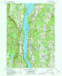
 1980 Kingston West1981 Print · USGSKingston and the Esopus Creek valley are shown here in the 1980s as the region balanced its colonial roots with modern infrastructure. Researchers can trace family sites at the Old Dutch Ch Cem, the old West Hurley District Sch No 8, or along the CONRAIL line.
 - 1980 Map of Hyde Park, 1981 Print
 1980 Hyde Park1981 Print · USGSDutchess and Ulster counties meet along the Hudson River in the early eighties, showcasing a landscape of historic estates and religious seminaries. Genealogists can trace the Stoutenburgh Cem, locate the F D Roosevelt Home National Historic Site, or explore landmarks like Indian Rock.2 unique versions available
 - 1982 Map of Grahamsville
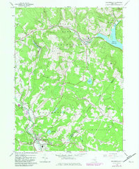 1982 Grahamsville1982 Print · USGSSullivan County and the Catskills are shown in the early 1980s during a period of established reservoir management and forest preservation. Researchers can trace the development of Grahamsville, locate the Rural Cem, and explore the grounds of the Woodbourne Correctional Institute.
 - 1985 Map of Waterbury, 1986 Print
 1985 Waterbury1986 Print · USGSThe Western Connecticut highlands and the Hudson Valley are captured in the mid-1980s, showing a landscape of deep forests and industrial river towns. Genealogists can trace family connections from Waterbury up through Litchfield and Torrington, while exploring the vast Barkhamsted Reservoir and Candlewood Lake basins.
 - 1986 Map of Pepacton Reservoir
 1986 Pepacton Reservoir1986 Print · USGSThe Catskills in the mid-eighties show a landscape shaped by the Pepacton Reservoir and protected wilderness. Local historians can trace mountain rail corridors like the Delaware & Ulster RR and locate high-elevation landmarks from Slide Mountain to Hunter Mountain.2 unique versions available
 - 1986 Map of Monticello
 1986 Monticello1986 Print · USGSThe Catskills and Shawangunk Ridge meet in the mid-eighties, showing a landscape defined by massive reservoirs and valley towns. Genealogists and researchers can trace the growth of Monticello, Ellenville, and New Paltz alongside landmarks like Mohonk Preserve and Stewart Airport.2 unique versions available
 - 1986 Map of Pittsfield
 1986 Pittsfield1986 Print · USGSThe Berkshires and the Hudson Valley meet in the mid-1980s, documenting a cross-border landscape of mountain forests and river towns. Genealogists and historians can trace the paths of Conrail and the Taconic State Parkway as they pass through Stockbridge, Great Barrington, and Kinderhook.2 unique versions available
End of results
Showing maps 1-7 of 7
Top cities of Ulster County
- Kingston historical maps
- Saugerties historical maps
- New Paltz historical maps
- Shawangunk historical maps
- Wawarsing historical maps
- Ulster historical maps
See more
Frequently asked questions
- What are the different types of historical maps available for Ulster County?
- What is the oldest map of Ulster County?
- Where can I purchase historical maps of Ulster County for my home or office?
- Where can I download high-res historical maps of Ulster County?
- Are there historical topographic maps available for Ulster County?
- Is there historical aerial imagery available for Ulster County?
- Where are historical maps of Ulster County sourced from?