Old Maps of Camden County, North Carolina
Explore 41 old maps of Camden County, spanning from 1919 to today. These high-resolution historic maps reveal how streets, neighborhoods, landmarks, and natural features evolved over time — perfect for genealogy, metal detecting, research, and local history exploration.
What you can do with these maps:
- See how Camden County changed over time: Compare historical maps to modern-day views to trace roads, homesites, rail lines & more.
- View detailed metadata: Each map includes creators, publishers, year, scale, and archive source.
- Overlay maps with satellite & LiDAR: Visualize the past alongside modern tools to explore terrain & human change.
- Trusted historical sources: Maps sourced from the USGS, Library of Congress, and other archives.
- Access maps your way: View online, download high-res files, or order prints for personal or research use.
Start exploring old maps of Camden County to uncover forgotten places, hidden landmarks, and the deep history beneath your feet.
Camden County, NC maps
(41)- 1919 Map of Suffolk
 1919 Suffolk1919 Print · USGSCovers Camden County, including Suffolk, Westhaven Lakes, and other nearby areas3 unique versions available
 - 1940 Map of Barco
 1940 Barco1940 Print · USGSCovers Camden County, including Coinjock, Bertha, and other nearby areas2 unique versions available
 - 1940 Map of Powells Point
 1940 Powells Point1940 Print · USGSCovers Camden County, including Grandy, Duck, and other nearby areas2 unique versions available
 - 1940 Map of Lake Drummond, 1964 Print
 1940 Lake Drummond1964 Print · USGSCovers Camden County, including Pasquotank County, Currituck County, and other nearby areas
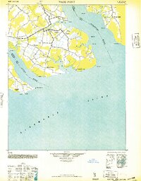
 - 1940 Map of Wade Point, 1973 Print
 1940 Wade Point1973 Print · USGSCovers Camden County, including Symonds Creek, Listers Corner, and other nearby areas
 - 1940 Map of South Mills, 1976 Print
 1940 South Mills1976 Print · USGSCovers Camden County, including Elizabeth City, South Mills, and other nearby areas
 - 1943 Map of Wade Point
 1943 Wade Point1943 Print · USGSCovers Camden County, including Symonds Creek, Listers Corner, and other nearby areas
 - 1945 Map of Lake Drummond
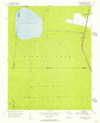
 1945 Lake Drummond1945 Print · USGSCovers Camden County, including Pasquotank County, Currituck County, and other nearby areas
 - 1946 Map of Eastville, 1971 Print
 1946 Eastville1971 Print · USGSCovers Camden County, including Virginia Beach, Kill Devil Hills, and other nearby areas
 - 1946 Map of Currituck Sound, 1980 Print
 1946 Currituck Sound1980 Print · USGSCovers Camden County, including Virginia Beach, Kill Devil Hills, and other nearby areas
 - 1948 Map of Wade Point
 1948 Wade Point1948 Print · USGSCovers Camden County, including Symonds Creek, Listers Corner, and other nearby areas2 unique versions available
 - 1948 Map of Elizabeth City
 1948 Elizabeth City1948 Print · USGSCovers Camden County, including Elizabeth City, Moyock, and other nearby areas2 unique versions available
 - 1952 Map of South Mills
 1952 South Mills1952 Print · USGSCovers Camden County, including Elizabeth City, South Mills, and other nearby areas
 - 1953 Map of Norfolk, 1954 Print
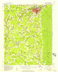
 1953 Norfolk1954 Print · USGSCovers Camden County, including Chesapeake, Norfolk, and other nearby areas4 unique versions available
 - 1954 Map of Corapeake, 1955 Print
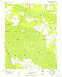
 1954 Corapeake1955 Print · USGSCovers Camden County, including Parkers Fork, Holly Grove, and other nearby areas
 - 1954 Map of Lake Drummond, 1956 Print
 1954 Lake Drummond1956 Print · USGSCovers Camden County, including Pasquotank County, Gates County, and other nearby areas2 unique versions available
 - 1954 Map of Lake Drummond SE, 1956 Print
 1954 Lake Drummond SE1956 Print · USGSCovers Camden County, including Currituck County, Chesapeake, and other nearby areas3 unique versions available
 - 1954 Map of Suffolk, 1958 Print
 1954 Suffolk1958 Print · USGSCovers Camden County, including Suffolk, Westhaven Lakes, and other nearby areas2 unique versions available
 - 1961 Map of Eastville
 1961 Eastville1961 Print · USGSCovers Camden County, including Virginia Beach, Kill Devil Hills, and other nearby areas
 - 1966 Map of Eastville
 1966 Eastville1966 Print · USGSCovers Camden County, including Virginia Beach, Kill Devil Hills, and other nearby areas
 - 1977 Map of Lake Drummond SE, 1978 Print
 1977 Lake Drummond SE1978 Print · USGSCovers Camden County, including Currituck County, Chesapeake, and other nearby areas
 - 1977 Map of Corapeake, 1978 Print
 1977 Corapeake1978 Print · USGSCovers Camden County, including Parkers Fork, Holly Grove, and other nearby areas2 unique versions available
 - 1977 Map of Lake Drummond, 1978 Print
 1977 Lake Drummond1978 Print · USGSCovers Camden County, including Pasquotank County, Gates County, and other nearby areas2 unique versions available
 - 1982 Map of South Mills
 1982 South Mills1982 Print · USGSCovers Camden County, including South Mills, Burnt Mills, and other nearby areas
 - 1982 Map of Pasquotank
 1982 Pasquotank1982 Print · USGSCovers Camden County, including Elizabeth City, Pasquotank, and other nearby areas
Showing maps 1-25 of 41
Top cities of Camden County
Frequently asked questions
- What are the different types of historical maps available for Camden County?
- What is the oldest map of Camden County?
- Where can I purchase historical maps of Camden County for my home or office?
- Where can I download high-res historical maps of Camden County?
- Are there historical topographic maps available for Camden County?
- Is there historical aerial imagery available for Camden County?
- Where are historical maps of Camden County sourced from?