1930s Maps of Brasstown, North Carolina
Explore 3 historic maps of Brasstown from the 1930s. These maps offer a rare glimpse into what life looked like during the 1930s — showing old roads, neighborhoods, homes, and landmarks that have changed or disappeared over time.
Whether you're researching your family's past, planning a metal detecting trip, or studying how Brasstown's landscape evolved across the 1930s, these high-resolution maps are a powerful tool for exploring the history of this region.
- Focus on a specific era: All maps on this page are from the 1930s, giving you a focused view of this time period.
- See what’s changed: Compare century-old streets, trails, and buildings to today's modern landscape using overlays and satellite layers.
- Research with precision: Use these maps for genealogy, historical research, land use analysis, or educational projects.
- View, download, or print: Maps are fully viewable online in high resolution, and can be downloaded or printed for your own records.
Start exploring Brasstown's history through authentic maps from the 1930s. This is your window into the past.
Brasstown, NC maps
(3)- 1935 Map of Peachtree
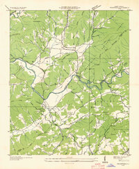 1935 Peachtree1935 Print · USGSCherokee and Clay counties appear here in the mid-1930s, showing the mountain communities along the Hiwassee River. Genealogists and historians can locate the John C Campbell Folk Sch, Sally Nebo Ch, and the site of Andrews Dam.
 - 1937 Map of Peachtree, 1957 Print
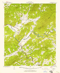 1937 Peachtree1957 Print · USGSWestern North Carolina's river valleys and mountain ridges are captured in the late 1930s as agricultural life centered around Brasstown and Peachtree. Researchers can locate historic rural sites like the Campbell Folk School, Jones Mill, and Wells Cem.4 unique versions available
 - 1938 Map of Peachtree
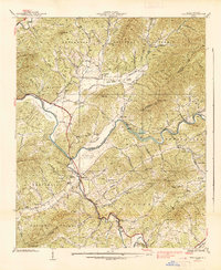 1938 Peachtree1938 Print · USGSCherokee and Clay Counties are shown here in the late thirties, a period when rural electrification projects began to intersect with traditional mountain communities. Genealogists can locate family landmarks like the Campbell Folk School, Wells Cem, and many local congregations including Mission Ch.
End of results
Showing maps 1-3 of 3
Top cities near Brasstown
- Andrews historical maps
- Murphy historical maps
- Hiawassee historical maps
- Blairsville historical maps
- Young Harris historical maps
- Hayesville historical maps
Frequently asked questions
- What are the different types of historical maps available for Brasstown?
- What is the oldest map of Brasstown?
- Where can I purchase historical maps of Brasstown for my home or office?
- Where can I download high-res historical maps of Brasstown?
- Are there historical topographic maps available for Brasstown?
- Is there historical aerial imagery available for Brasstown?
- Where are historical maps of Brasstown sourced from?