1950s Maps of Beaver Creek, Fayetteville
Explore 5 historic maps of Beaver Creek from the 1950s. These maps offer a rare glimpse into what life looked like during the 1950s — showing old roads, neighborhoods, homes, and landmarks that have changed or disappeared over time.
Whether you're researching your family's past, planning a metal detecting trip, or studying how Beaver Creek's landscape evolved across the 1950s, these high-resolution maps are a powerful tool for exploring the history of this region.
- Focus on a specific era: All maps on this page are from the 1950s, giving you a focused view of this time period.
- See what’s changed: Compare century-old streets, trails, and buildings to today's modern landscape using overlays and satellite layers.
- Research with precision: Use these maps for genealogy, historical research, land use analysis, or educational projects.
- View, download, or print: Maps are fully viewable online in high resolution, and can be downloaded or printed for your own records.
Start exploring Beaver Creek's history through authentic maps from the 1950s. This is your window into the past.
Beaver Creek, Fayetteville maps
(5)- 1950 Map of Fayetteville
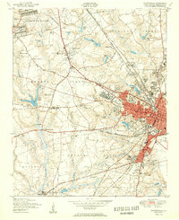 1950 Fayetteville1950 Print · USGSMid-century Fayetteville is a bustling hub where the growing city limits meet the rural traditions of Cumberland County. Genealogists and historians can trace the foundations of local neighborhoods through sites like the State Teachers College, McPhersons Ch Cem, and the old rail stop at Skibo Station.2 unique versions available
 - 1953 Map of Raleigh, 1965 Print
 1953 Raleigh1965 Print · USGSCentral North Carolina in the early sixties shows a landscape of growing towns and military hubs before the full expansion of the interstate system. Genealogists can trace family footprints across the Piedmont through Wake Forest, Siler City, and the large Fort Bragg Military Reservation.4 unique versions available
 - 1954 Map of Raleigh
 1954 Raleigh1954 Print · USGSThe North Carolina Piedmont and Sandhills are captured in the mid-fifties during a period of steady regional growth. Genealogists and historians can trace the development of towns like Siler City or locate landmarks such as Falls of Neuse and Camp Mackall.
 - 1957 Map of Fayetteville, 1960 Print
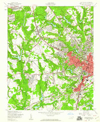 1957 Fayetteville1960 Print · USGSFayetteville at the peak of the post-war era shows a bustling city expanding toward the Fort Bragg Military Reservation. Genealogists and historians can trace old neighborhoods like Haymount, locate institutions like the State Teachers College, and find family landmarks like Lafayette Memorial Cem.5 unique versions available
 - 1957 Map of Fayetteville, 1961 Print
 1957 Fayetteville1961 Print · USGSThe Cape Fear River valley and Fayetteville's growing suburbs are captured here in the late fifties, showing the expanding footprint of the Fort Bragg Military Reservation. Genealogists can trace early neighborhood development and rural landmarks like Lakedale, Manchester, and Central High Sch.2 unique versions available
End of results
Showing maps 1-5 of 5
Top cities near Beaver Creek
- Fayetteville historical maps
- Linden Oaks historical maps
- Hope Mills historical maps
- Spring Lake historical maps
- Raeford historical maps
- Parkton historical maps
See more
Frequently asked questions
- What are the different types of historical maps available for Beaver Creek?
- What is the oldest map of Beaver Creek?
- Where can I purchase historical maps of Beaver Creek for my home or office?
- Where can I download high-res historical maps of Beaver Creek?
- Are there historical topographic maps available for Beaver Creek?
- Is there historical aerial imagery available for Beaver Creek?
- Where are historical maps of Beaver Creek sourced from?