1970s Maps of Denton, North Carolina
Explore 2 historic maps of Denton from the 1970s. These maps offer a rare glimpse into what life looked like during the 1970s — showing old roads, neighborhoods, homes, and landmarks that have changed or disappeared over time.
Whether you're researching your family's past, planning a metal detecting trip, or studying how Denton's landscape evolved across the 1970s, these high-resolution maps are a powerful tool for exploring the history of this region.
- Focus on a specific era: All maps on this page are from the 1970s, giving you a focused view of this time period.
- See what’s changed: Compare century-old streets, trails, and buildings to today's modern landscape using overlays and satellite layers.
- Research with precision: Use these maps for genealogy, historical research, land use analysis, or educational projects.
- View, download, or print: Maps are fully viewable online in high resolution, and can be downloaded or printed for your own records.
Start exploring Denton's history through authentic maps from the 1970s. This is your window into the past.
Denton, NC maps
(2)- 1977 Map of High Rock, 1979 Print
 1977 High Rock1979 Print · USGSCentral North Carolina in the late seventies is captured here through aerial photography, showing the rural riverfront before modern suburban expansion. Researchers can trace land ownership patterns and rural crossroads near Healing Springs, Jackson Hill, and along the banks of the Yadkin River.
 - 1977 Map of Denton NW, 1979 Print
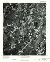 1977 Denton NW1979 Print · USGSThe rural stretches of Davidson County are captured in the late seventies as the region balanced its agricultural roots with the presence of High Rock Lake. Researchers can trace the wooded terrain of Wildcat Mountain and old settlement sites like Silver Hill and Cedar Grove.
End of results
Showing maps 1-2 of 2
Top cities near Denton
- Thomasville historical maps
- Asheboro historical maps
- Lexington historical maps
- Archdale historical maps
- Trinity historical maps
- Misenheimer historical maps
See more
Top neighborhoods of Denton
Frequently asked questions
- What are the different types of historical maps available for Denton?
- What is the oldest map of Denton?
- Where can I purchase historical maps of Denton for my home or office?
- Where can I download high-res historical maps of Denton?
- Are there historical topographic maps available for Denton?
- Is there historical aerial imagery available for Denton?
- Where are historical maps of Denton sourced from?