1950s Maps of Dolcetto, Davidson County
Explore 4 historic maps of Dolcetto from the 1950s. These maps offer a rare glimpse into what life looked like during the 1950s — showing old roads, neighborhoods, homes, and landmarks that have changed or disappeared over time.
Whether you're researching your family's past, planning a metal detecting trip, or studying how Dolcetto's landscape evolved across the 1950s, these high-resolution maps are a powerful tool for exploring the history of this region.
- Focus on a specific era: All maps on this page are from the 1950s, giving you a focused view of this time period.
- See what’s changed: Compare century-old streets, trails, and buildings to today's modern landscape using overlays and satellite layers.
- Research with precision: Use these maps for genealogy, historical research, land use analysis, or educational projects.
- View, download, or print: Maps are fully viewable online in high resolution, and can be downloaded or printed for your own records.
Start exploring Dolcetto's history through authentic maps from the 1950s. This is your window into the past.
Dolcetto, Davidson County maps
(4)- 1950 Map of Lexington West, 1969 Print
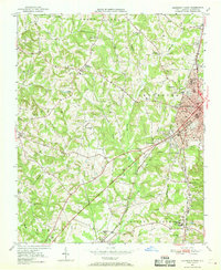 1950 Lexington West1969 Print · USGSWestern Davidson County at the mid-century shows a landscape of growing mill towns and rural communities. Genealogists can trace family landmarks like Erlanger, Robbins Sch, and Pauls Chapel along the Southern railroad line.3 unique versions available
 - 1951 Map of Lexington West
 1951 Lexington West1951 Print · USGSMid-century Davidson County comes alive in this survey of western Lexington and the surrounding townships during a period of steady post-war growth. Researchers can trace the footprints of communities like Erlanger and Reeds Crossroads or locate family sites at Owens Cemetery and Pauls Chapel.
 - 1953 Map of Charlotte, 1968 Print
 1953 Charlotte1968 Print · USGSThe North Carolina Piedmont and South Carolina borderlands are shown in detail during a period of significant growth and reservoir development. Trace the rail corridors of the Southern Railway or find family roots in towns like China Grove, Misenheimer, and Lincolnton.3 unique versions available
 - 1954 Map of Charlotte
 1954 Charlotte1954 Print · USGSThe North Carolina Piedmont in the mid-1950s shows a region of rapid growth and industrial expansion centered around Charlotte. Trace the era's infrastructure through the Southern railroad lines and locate significant landmarks like the Charlotte Naval Ammunition Depot and Lake Norman.2 unique versions available
End of results
Showing maps 1-4 of 4
Frequently asked questions
- What are the different types of historical maps available for Dolcetto?
- What is the oldest map of Dolcetto?
- Where can I purchase historical maps of Dolcetto for my home or office?
- Where can I download high-res historical maps of Dolcetto?
- Are there historical topographic maps available for Dolcetto?
- Is there historical aerial imagery available for Dolcetto?
- Where are historical maps of Dolcetto sourced from?