1950s Maps of Thomasville, North Carolina
Explore 5 historic maps of Thomasville from the 1950s. These maps offer a rare glimpse into what life looked like during the 1950s — showing old roads, neighborhoods, homes, and landmarks that have changed or disappeared over time.
Whether you're researching your family's past, planning a metal detecting trip, or studying how Thomasville's landscape evolved across the 1950s, these high-resolution maps are a powerful tool for exploring the history of this region.
- Focus on a specific era: All maps on this page are from the 1950s, giving you a focused view of this time period.
- See what’s changed: Compare century-old streets, trails, and buildings to today's modern landscape using overlays and satellite layers.
- Research with precision: Use these maps for genealogy, historical research, land use analysis, or educational projects.
- View, download, or print: Maps are fully viewable online in high resolution, and can be downloaded or printed for your own records.
Start exploring Thomasville's history through authentic maps from the 1950s. This is your window into the past.
Thomasville, NC maps
(5)- 1950 Map of Lexington East, 1965 Print
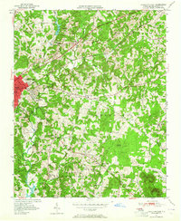 1950 Lexington East1965 Print · USGSDavidson County at mid-century shows a landscape of growing towns and established rural crossroads before major highway expansions. Genealogists can trace family landmarks like Old Becks Ch, the County Home, and the former Dunbar Sch.4 unique versions available
 - 1951 Map of Lexington East
 1951 Lexington East1951 Print · USGSDavidson County at mid-century reveals a landscape of rural crossroads and growing industry south of the main rail corridors. Researchers can trace ancestral locations at Old Becks Ch, locate the State Prison Camp No 602, or study the early shoreline of High Rock Lake.
 - 1951 Map of Fair Grove, 1952 Print
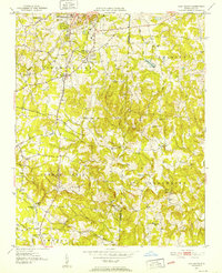 1951 Fair Grove1952 Print · USGSDavidson County in the early fifties is mapped here as a network of rail-side stations and rural parish life. Genealogists can locate family landmarks like Hannersville Station, Loflin Store, and Clarksbury Ch along the historic rail corridors.4 unique versions available
 - 1953 Map of Charlotte, 1968 Print
 1953 Charlotte1968 Print · USGSThe North Carolina Piedmont and South Carolina borderlands are shown in detail during a period of significant growth and reservoir development. Trace the rail corridors of the Southern Railway or find family roots in towns like China Grove, Misenheimer, and Lincolnton.3 unique versions available
 - 1954 Map of Charlotte
 1954 Charlotte1954 Print · USGSThe North Carolina Piedmont in the mid-1950s shows a region of rapid growth and industrial expansion centered around Charlotte. Trace the era's infrastructure through the Southern railroad lines and locate significant landmarks like the Charlotte Naval Ammunition Depot and Lake Norman.2 unique versions available
End of results
Showing maps 1-5 of 5
Top cities near Thomasville
- Greensboro historical maps
- Winston-Salem historical maps
- High Point historical maps
- Asheboro historical maps
- Kernersville historical maps
- Lexington historical maps
See more
Top neighborhoods of Thomasville
- Fairgrove Forest historical maps
- Glen Anna historical maps
- Fair Grove historical maps
- Pilot historical maps
- Erwin Heights historical maps
- Johnsontown historical maps
See more
Frequently asked questions
- What are the different types of historical maps available for Thomasville?
- What is the oldest map of Thomasville?
- Where can I purchase historical maps of Thomasville for my home or office?
- Where can I download high-res historical maps of Thomasville?
- Are there historical topographic maps available for Thomasville?
- Is there historical aerial imagery available for Thomasville?
- Where are historical maps of Thomasville sourced from?