1940s Maps of Jenkins Meadow, North Carolina
Explore 2 historic maps of Jenkins Meadow from the 1940s. These maps offer a rare glimpse into what life looked like during the 1940s — showing old roads, neighborhoods, homes, and landmarks that have changed or disappeared over time.
Whether you're researching your family's past, planning a metal detecting trip, or studying how Jenkins Meadow's landscape evolved across the 1940s, these high-resolution maps are a powerful tool for exploring the history of this region.
- Focus on a specific era: All maps on this page are from the 1940s, giving you a focused view of this time period.
- See what’s changed: Compare century-old streets, trails, and buildings to today's modern landscape using overlays and satellite layers.
- Research with precision: Use these maps for genealogy, historical research, land use analysis, or educational projects.
- View, download, or print: Maps are fully viewable online in high resolution, and can be downloaded or printed for your own records.
Start exploring Jenkins Meadow's history through authentic maps from the 1940s. This is your window into the past.
Jenkins Meadow, NC maps
(2)- 1940 Map of Tapoco, 1956 Print
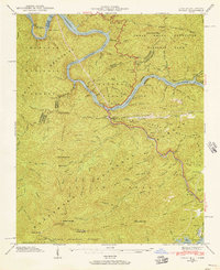 1940 Tapoco1956 Print · USGSThe Tennessee and North Carolina borderlands come alive in the 1940s as hydroelectric power and federal forest conservation reshape the mountains. Trace historic family sites and early infrastructure including Orr Cemetery, Beers School, and the Calderwood Dam.5 unique versions available
 - 1941 Map of Tapoco
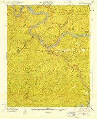 1941 Tapoco1941 Print · USGSThe Little Tennessee River border between North Carolina and Tennessee is captured here during the 1940s buildup of hydroelectric power. Genealogists and hikers can trace the Appalachian Trail through Deals Gap or locate remote sites like Beers Sch and Orr Cem.
End of results
Showing maps 1-2 of 2
Top cities near Jenkins Meadow
- Andrews historical maps
- Robbinsville historical maps
- Lake Santeetlah historical maps
- Fontana Dam historical maps
Frequently asked questions
- What are the different types of historical maps available for Jenkins Meadow?
- What is the oldest map of Jenkins Meadow?
- Where can I purchase historical maps of Jenkins Meadow for my home or office?
- Where can I download high-res historical maps of Jenkins Meadow?
- Are there historical topographic maps available for Jenkins Meadow?
- Is there historical aerial imagery available for Jenkins Meadow?
- Where are historical maps of Jenkins Meadow sourced from?