1970s Maps of Jefferson Gardens, Greensboro
Explore 2 historic maps of Jefferson Gardens from the 1970s. These maps offer a rare glimpse into what life looked like during the 1970s — showing old roads, neighborhoods, homes, and landmarks that have changed or disappeared over time.
Whether you're researching your family's past, planning a metal detecting trip, or studying how Jefferson Gardens's landscape evolved across the 1970s, these high-resolution maps are a powerful tool for exploring the history of this region.
- Focus on a specific era: All maps on this page are from the 1970s, giving you a focused view of this time period.
- See what’s changed: Compare century-old streets, trails, and buildings to today's modern landscape using overlays and satellite layers.
- Research with precision: Use these maps for genealogy, historical research, land use analysis, or educational projects.
- View, download, or print: Maps are fully viewable online in high resolution, and can be downloaded or printed for your own records.
Start exploring Jefferson Gardens's history through authentic maps from the 1970s. This is your window into the past.
Jefferson Gardens, Greensboro maps
(2)- 1977 Map of Greensboro, 1979 Print
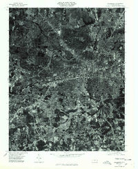 1977 Greensboro1979 Print · USGSGreensboro is documented here in the late seventies during a period of significant suburban infill. Researchers can trace the mid-century development of neighborhoods like Hamilton Lakes, Edgeville, and the southern settlement of Vandalia.
 - 1977 Map of Guilford, 1979 Print
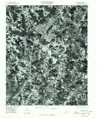 1977 Guilford1979 Print · USGSGuilford County underwent rapid transformation in the late seventies as residential neighborhoods expanded into the Piedmont countryside. Genealogists and historians can trace the precise development of Friendship, Sandy Ridge, and the Sedgefield area through this detailed aerial photography.
End of results
Showing maps 1-2 of 2
Frequently asked questions
- What are the different types of historical maps available for Jefferson Gardens?
- What is the oldest map of Jefferson Gardens?
- Where can I purchase historical maps of Jefferson Gardens for my home or office?
- Where can I download high-res historical maps of Jefferson Gardens?
- Are there historical topographic maps available for Jefferson Gardens?
- Is there historical aerial imagery available for Jefferson Gardens?
- Where are historical maps of Jefferson Gardens sourced from?