1900s (20th Century) Maps of Riverdale Ridge, Greensboro
Explore 8 historic maps of Riverdale Ridge from the 1900s (20th Century). These maps offer a rare glimpse into what life looked like during the 1900s — showing old roads, neighborhoods, homes, and landmarks that have changed or disappeared over time.
Whether you're researching your family's past, planning a metal detecting trip, or studying how Riverdale Ridge's landscape evolved across the 1900s, these high-resolution maps are a powerful tool for exploring the history of this region.
- Focus on a specific era: All maps on this page are from the 1900s, giving you a focused view of this time period.
- See what’s changed: Compare century-old streets, trails, and buildings to today's modern landscape using overlays and satellite layers.
- Research with precision: Use these maps for genealogy, historical research, land use analysis, or educational projects.
- View, download, or print: Maps are fully viewable online in high resolution, and can be downloaded or printed for your own records.
Start exploring Riverdale Ridge's history through authentic maps from the 1900s. This is your window into the past.
Riverdale Ridge, Greensboro maps
(8)- 1951 Map of Greensboro, 1953 Print
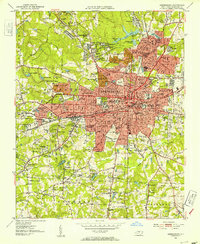 1951 Greensboro1953 Print · USGSMid-century Greensboro is documented here as a significant regional center of education and industry. Researchers can trace the footprints of A & T College, locate family plots at Cone Cam, and explore the textile-era neighborhoods of Revolution and White Oak.5 unique versions available
 - 1953 Map of Greensboro, 1981 Print
 1953 Greensboro1981 Print · USGSThe Piedmont borderlands of North Carolina and Virginia show a landscape defined by new reservoirs and old rail lines. Trace family roots and the changing river geography through Elon College, the John H Kerr Reservoir, and South Boston.
 - 1954 Map of Greensboro
 1954 Greensboro1954 Print · USGSThe Piedmont borderlands of North Carolina and Virginia come alive in this mid-fifties study of a region defined by its rivers and rails. Researchers can trace the growing Buggs Island Lake or follow the paths of the Southern Ry and Seaboard Air Line RR through towns like Oxford and Reidsville.
 - 1962 Map of Greensboro
 1962 Greensboro1962 Print · USGSThe Piedmont region along the Virginia and North Carolina border comes alive in the early 1960s, showing a landscape defined by industry and new reservoirs. Trace the path of the Virginian RR or explore the early development of Greensboro and Durham.
 - 1966 Map of Greensboro
 1966 Greensboro1966 Print · USGSThe North Carolina and Virginia Piedmont thrives during the mid-sixties, showcasing a landscape of textile hubs and expanding river reservoirs. Researchers can trace the rail corridors of the Southern Railway, find local landmarks like Elon College, or locate the extensive Camp Butner Military Reservation.
 - 1977 Map of Greensboro, 1979 Print
 1977 Greensboro1979 Print · USGSGreensboro is documented here in the late seventies during a period of significant suburban infill. Researchers can trace the mid-century development of neighborhoods like Hamilton Lakes, Edgeville, and the southern settlement of Vandalia.
 - 1984 Map of Greensboro
 1984 Greensboro1984 Print · USGSThe North Carolina Piedmont in the mid-eighties shows a region of growing urban centers and vital water resources. Local historians can trace the development of Greensboro, locate the Elon College campus, or explore the grounds of Guilford Courthouse National Military Park.
 - 1997 Map of Greensboro, 2001 Print
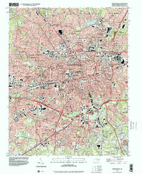 1997 Greensboro2001 Print · USGSGreensboro and its surrounding mill villages appear at a peak of late-century development, blending urban density with historic industrial neighborhoods. Genealogists and historians can trace family roots through specific sites like Bennett College, White Oak, and Pomona.
End of results
Showing maps 1-8 of 8
Frequently asked questions
- What are the different types of historical maps available for Riverdale Ridge?
- What is the oldest map of Riverdale Ridge?
- Where can I purchase historical maps of Riverdale Ridge for my home or office?
- Where can I download high-res historical maps of Riverdale Ridge?
- Are there historical topographic maps available for Riverdale Ridge?
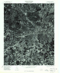
- Is there historical aerial imagery available for Riverdale Ridge?
- Where are historical maps of Riverdale Ridge sourced from?