1940s Maps of Bethel, North Carolina
Explore 2 historic maps of Bethel from the 1940s. These maps offer a rare glimpse into what life looked like during the 1940s — showing old roads, neighborhoods, homes, and landmarks that have changed or disappeared over time.
Whether you're researching your family's past, planning a metal detecting trip, or studying how Bethel's landscape evolved across the 1940s, these high-resolution maps are a powerful tool for exploring the history of this region.
- Focus on a specific era: All maps on this page are from the 1940s, giving you a focused view of this time period.
- See what’s changed: Compare century-old streets, trails, and buildings to today's modern landscape using overlays and satellite layers.
- Research with precision: Use these maps for genealogy, historical research, land use analysis, or educational projects.
- View, download, or print: Maps are fully viewable online in high resolution, and can be downloaded or printed for your own records.
Start exploring Bethel's history through authentic maps from the 1940s. This is your window into the past.
Bethel, NC maps
(2)- 1941 Map of Waynesville, 1956 Print
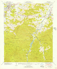 1941 Waynesville1956 Print · USGSWaynesville and the surrounding Blue Ridge coves are captured here in the early 1940s as the regional economy balanced valley industry with mountain resources. Genealogists and hikers can trace family sites like Ratcliff Cove Ch, the Big Ridge Mine, and Lake Logan.3 unique versions available
 - 1942 Map of Waynesville
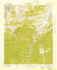 1942 Waynesville1942 Print · USGSWaynesville and the high peaks of the Blue Ridge are captured here in the early 1940s as the regional timber and mountain economy matured. Genealogists can locate family landmarks like Elizabeth Chapel, Greenhill Cem, and the rural Cecil Sch.2 unique versions available
End of results
Showing maps 1-2 of 2
Top cities near Bethel
- Waynesville historical maps
- Brevard historical maps
- Canton historical maps
- Clyde historical maps
- Maggie Valley historical maps
Frequently asked questions
- What are the different types of historical maps available for Bethel?
- What is the oldest map of Bethel?
- Where can I purchase historical maps of Bethel for my home or office?
- Where can I download high-res historical maps of Bethel?
- Are there historical topographic maps available for Bethel?
- Is there historical aerial imagery available for Bethel?
- Where are historical maps of Bethel sourced from?