1940s Maps of Fines Creek, North Carolina
Explore 2 historic maps of Fines Creek from the 1940s. These maps offer a rare glimpse into what life looked like during the 1940s — showing old roads, neighborhoods, homes, and landmarks that have changed or disappeared over time.
Whether you're researching your family's past, planning a metal detecting trip, or studying how Fines Creek's landscape evolved across the 1940s, these high-resolution maps are a powerful tool for exploring the history of this region.
- Focus on a specific era: All maps on this page are from the 1940s, giving you a focused view of this time period.
- See what’s changed: Compare century-old streets, trails, and buildings to today's modern landscape using overlays and satellite layers.
- Research with precision: Use these maps for genealogy, historical research, land use analysis, or educational projects.
- View, download, or print: Maps are fully viewable online in high resolution, and can be downloaded or printed for your own records.
Start exploring Fines Creek's history through authentic maps from the 1940s. This is your window into the past.
Fines Creek, NC maps
(2)- 1941 Map of Hepco, 1957 Print
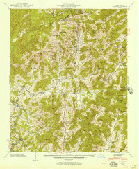 1941 Hepco1957 Print · USGSWestern North Carolina's high country during the early 1940s shows a landscape of isolated mountain coves and tight-knit communities. Researchers can locate the early centers of local life at Fines Creek Ch, the settlement of Hepco, and the high ridges of Sandymush Bald.
 - 1942 Map of Hepco
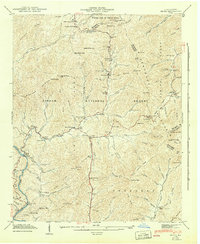 1942 Hepco1942 Print · USGSNorth Carolina's high mountain hollows are documented here during the early 1940s, showing the intersection of three counties and the Pisgah National Forest. Genealogists can locate community centers like Fines Creek Sch, James Chapel, and the isolated Pine Grove Cem.2 unique versions available
End of results
Showing maps 1-2 of 2
Top cities near Fines Creek
- Waynesville historical maps
- Canton historical maps
- Clyde historical maps
- Maggie Valley historical maps
- Hot Springs historical maps
Frequently asked questions
- What are the different types of historical maps available for Fines Creek?
- What is the oldest map of Fines Creek?
- Where can I purchase historical maps of Fines Creek for my home or office?
- Where can I download high-res historical maps of Fines Creek?
- Are there historical topographic maps available for Fines Creek?
- Is there historical aerial imagery available for Fines Creek?
- Where are historical maps of Fines Creek sourced from?