1940s Maps of Dillsboro, North Carolina
Explore 3 historic maps of Dillsboro from the 1940s. These maps offer a rare glimpse into what life looked like during the 1940s — showing old roads, neighborhoods, homes, and landmarks that have changed or disappeared over time.
Whether you're researching your family's past, planning a metal detecting trip, or studying how Dillsboro's landscape evolved across the 1940s, these high-resolution maps are a powerful tool for exploring the history of this region.
- Focus on a specific era: All maps on this page are from the 1940s, giving you a focused view of this time period.
- See what’s changed: Compare century-old streets, trails, and buildings to today's modern landscape using overlays and satellite layers.
- Research with precision: Use these maps for genealogy, historical research, land use analysis, or educational projects.
- View, download, or print: Maps are fully viewable online in high resolution, and can be downloaded or printed for your own records.
Start exploring Dillsboro's history through authentic maps from the 1940s. This is your window into the past.
Dillsboro, NC maps
(3)- 1940 Map of Greens Creek, 1957 Print
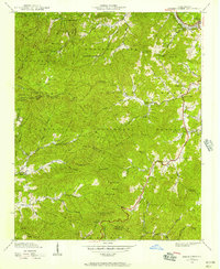 1940 Greens Creek1957 Print · USGSIn the early 1940s, these North Carolina mountain communities were connected by high gaps and winding creek forks. Local historians can trace the foundations of Pumpkintown or locate rural landmarks like Greens Creek Sch and the Lookout Tower on Cowee Bald.6 unique versions available
 - 1941 Map of Greens Creek
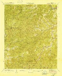 1941 Greens Creek1941 Print · USGSJackson County and the edges of the Great Smokies are captured here just before the mid-century, centered on the Tuckasegee River corridor. Researchers can locate early mountain schools and churches like Greens Creek School, Gay, and the Eagle Cem.
 - 1946 Map of Cullowhee, 1947 Print
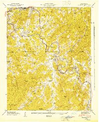 1946 Cullowhee1947 Print · USGSThe Tuckasegee River valley thrives shortly after the war, centered on the campus of Western Carolina Teachers College and the railroad hub at Sylva. Genealogists and historians can trace old homesteads and family burials at Parris Cem, Stillwell Cem, and the settlement at East Laport.8 unique versions available
End of results
Showing maps 1-3 of 3
Top cities near Dillsboro
- Waynesville historical maps
- Cullowhee historical maps
- Franklin historical maps
- Sylva historical maps
- Cherokee historical maps
- Bryson City historical maps
See more
Frequently asked questions
- What are the different types of historical maps available for Dillsboro?
- What is the oldest map of Dillsboro?
- Where can I purchase historical maps of Dillsboro for my home or office?
- Where can I download high-res historical maps of Dillsboro?
- Are there historical topographic maps available for Dillsboro?
- Is there historical aerial imagery available for Dillsboro?
- Where are historical maps of Dillsboro sourced from?