1940s Maps of Otto, North Carolina
Explore 2 historic maps of Otto from the 1940s. These maps offer a rare glimpse into what life looked like during the 1940s — showing old roads, neighborhoods, homes, and landmarks that have changed or disappeared over time.
Whether you're researching your family's past, planning a metal detecting trip, or studying how Otto's landscape evolved across the 1940s, these high-resolution maps are a powerful tool for exploring the history of this region.
- Focus on a specific era: All maps on this page are from the 1940s, giving you a focused view of this time period.
- See what’s changed: Compare century-old streets, trails, and buildings to today's modern landscape using overlays and satellite layers.
- Research with precision: Use these maps for genealogy, historical research, land use analysis, or educational projects.
- View, download, or print: Maps are fully viewable online in high resolution, and can be downloaded or printed for your own records.
Start exploring Otto's history through authentic maps from the 1940s. This is your window into the past.
Otto, NC maps
(2)- 1946 Map of Prentiss, 1957 Print
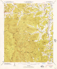 1946 Prentiss1957 Print · USGSMacon County's high ridges and river valleys are captured here just after the war, showing the intersection of mountain wilderness and rural industry. Genealogists and hikers can trace the Appalachian Trail across Albert Mtn or locate family sites like Newman Chapel and the Tallulah Falls Railroad.5 unique versions available
 - 1947 Map of Prentiss
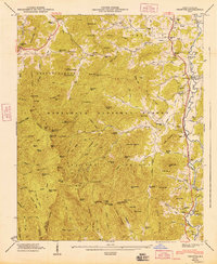 1947 Prentiss1947 Print · USGSMacon County in the late 1940s reveals a mountain landscape defined by small valley settlements and high-altitude timberlands. Genealogists can trace family roots through rural landmarks like Addington Mill, Maidens Chapel, and the Allison-Watts Sch.
End of results
Showing maps 1-2 of 2
Top cities near Otto
- Franklin historical maps
- Clayton historical maps
- Mountain City historical maps
- Tiger historical maps
- Dillard historical maps
- Sky Valley historical maps
Frequently asked questions
- What are the different types of historical maps available for Otto?
- What is the oldest map of Otto?
- Where can I purchase historical maps of Otto for my home or office?
- Where can I download high-res historical maps of Otto?
- Are there historical topographic maps available for Otto?
- Is there historical aerial imagery available for Otto?
- Where are historical maps of Otto sourced from?