1930s Maps of White Rock, North Carolina
Explore 2 historic maps of White Rock from the 1930s. These maps offer a rare glimpse into what life looked like during the 1930s — showing old roads, neighborhoods, homes, and landmarks that have changed or disappeared over time.
Whether you're researching your family's past, planning a metal detecting trip, or studying how White Rock's landscape evolved across the 1930s, these high-resolution maps are a powerful tool for exploring the history of this region.
- Focus on a specific era: All maps on this page are from the 1930s, giving you a focused view of this time period.
- See what’s changed: Compare century-old streets, trails, and buildings to today's modern landscape using overlays and satellite layers.
- Research with precision: Use these maps for genealogy, historical research, land use analysis, or educational projects.
- View, download, or print: Maps are fully viewable online in high resolution, and can be downloaded or printed for your own records.
Start exploring White Rock's history through authentic maps from the 1930s. This is your window into the past.
White Rock, NC maps
(2)- 1936 Map of White Rock
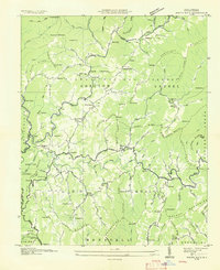 1936 White Rock1936 Print · USGSMadison County communities are captured here in the mid-1930s, showing a landscape of remote mountain hollows and ridge-top settlements. Researchers can locate family landmarks such as Middle Laurel Ch, Wallin Mill, and the small community of Sodom.
 - 1939 Map of White Rock, 1957 Print
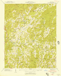 1939 White Rock1957 Print · USGSMadison County high country is documented here just before the war, showing the deep-hollow settlements and family landmarks of the Blue Ridge. Genealogists can trace ancestral sites at Gosnell Cem, the Rice Mill, and small mountain communities like Cutshalltown or Guntertown.5 unique versions available
End of results
Showing maps 1-2 of 2
Top cities near White Rock
- Greeneville historical maps
- Tusculum historical maps
- Mars Hill historical maps
- Mosheim historical maps
- Marshall historical maps
- Hot Springs historical maps
Frequently asked questions
- What are the different types of historical maps available for White Rock?
- What is the oldest map of White Rock?
- Where can I purchase historical maps of White Rock for my home or office?
- Where can I download high-res historical maps of White Rock?
- Are there historical topographic maps available for White Rock?
- Is there historical aerial imagery available for White Rock?
- Where are historical maps of White Rock sourced from?