1990s Maps of Stumptown, North Carolina
Explore 2 historic maps of Stumptown from the 1990s. These maps offer a rare glimpse into what life looked like during the 1990s — showing old roads, neighborhoods, homes, and landmarks that have changed or disappeared over time.
Whether you're researching your family's past, planning a metal detecting trip, or studying how Stumptown's landscape evolved across the 1990s, these high-resolution maps are a powerful tool for exploring the history of this region.
- Focus on a specific era: All maps on this page are from the 1990s, giving you a focused view of this time period.
- See what’s changed: Compare century-old streets, trails, and buildings to today's modern landscape using overlays and satellite layers.
- Research with precision: Use these maps for genealogy, historical research, land use analysis, or educational projects.
- View, download, or print: Maps are fully viewable online in high resolution, and can be downloaded or printed for your own records.
Start exploring Stumptown's history through authentic maps from the 1990s. This is your window into the past.
Stumptown, NC maps
(2)- 1993 Map of Marion East, 1996 Print
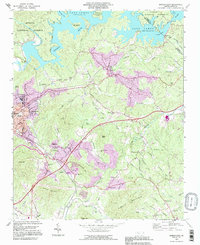 1993 Marion East1996 Print · USGSMcDowell County in the 1990s shows a landscape of growing communities and mountain industry between the Blue Ridge foothills and the waters of Lake James. Family historians can trace local landmarks like Nebo High Sch, Oak Grove Cem, and Parkers Chapel.
 - 1994 Map of Marion East, 1998 Print
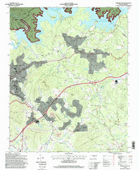 1994 Marion East1998 Print · USGSMcDowell County's eastern reaches are captured here in the mid-nineties, showing the integration of Lake James with the rail-side growth of Marion. Researchers can pinpoint local landmarks from the State Prison Camp to rural congregations like Drusilla Church and Fairview Church.
End of results
Showing maps 1-2 of 2
Top cities near Stumptown
- Morganton historical maps
- Marion historical maps
- Spruce Pine historical maps
- Nebo historical maps
- Glen Alpine historical maps
- Old Fort historical maps
Frequently asked questions
- What are the different types of historical maps available for Stumptown?
- What is the oldest map of Stumptown?
- Where can I purchase historical maps of Stumptown for my home or office?
- Where can I download high-res historical maps of Stumptown?
- Are there historical topographic maps available for Stumptown?
- Is there historical aerial imagery available for Stumptown?
- Where are historical maps of Stumptown sourced from?