1990s Maps of Brewers Crossroads, North Carolina
Explore 2 historic maps of Brewers Crossroads from the 1990s. These maps offer a rare glimpse into what life looked like during the 1990s — showing old roads, neighborhoods, homes, and landmarks that have changed or disappeared over time.
Whether you're researching your family's past, planning a metal detecting trip, or studying how Brewers Crossroads's landscape evolved across the 1990s, these high-resolution maps are a powerful tool for exploring the history of this region.
- Focus on a specific era: All maps on this page are from the 1990s, giving you a focused view of this time period.
- See what’s changed: Compare century-old streets, trails, and buildings to today's modern landscape using overlays and satellite layers.
- Research with precision: Use these maps for genealogy, historical research, land use analysis, or educational projects.
- View, download, or print: Maps are fully viewable online in high resolution, and can be downloaded or printed for your own records.
Start exploring Brewers Crossroads's history through authentic maps from the 1990s. This is your window into the past.
Brewers Crossroads, NC maps
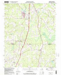
(2)- 1990 Map of Emporia
 1990 Emporia1990 Print · USGSThe Southside Virginia borderlands are captured here in the late twentieth century, showing the critical rail and river networks of the region. Genealogists and local historians can trace family roots through rural communities like Alberta, Boykins, and Dolphin along the Meherrin River.
 - 1997 Map of Skippers, 2000 Print
 1997 Skippers2000 Print · USGSThe borderlands of Virginia and North Carolina are preserved here as they appeared in the late twentieth century. Genealogists and historians can locate rural community hubs like Skippers, Turners Crossroads, and several family burial sites such as Wyche Cem.
End of results
Showing maps 1-2 of 2
Top cities near Brewers Crossroads
- Roanoke Rapids historical maps
- Emporia historical maps
- South Rosemary historical maps
- Weldon historical maps
- Garysburg historical maps
- Gaston historical maps
See more
Frequently asked questions
- What are the different types of historical maps available for Brewers Crossroads?
- What is the oldest map of Brewers Crossroads?
- Where can I purchase historical maps of Brewers Crossroads for my home or office?
- Where can I download high-res historical maps of Brewers Crossroads?
- Are there historical topographic maps available for Brewers Crossroads?
- Is there historical aerial imagery available for Brewers Crossroads?
- Where are historical maps of Brewers Crossroads sourced from?