1980s Maps of University Lake, Carrboro
Explore 2 historic maps of University Lake from the 1980s. These maps offer a rare glimpse into what life looked like during the 1980s — showing old roads, neighborhoods, homes, and landmarks that have changed or disappeared over time.
Whether you're researching your family's past, planning a metal detecting trip, or studying how University Lake's landscape evolved across the 1980s, these high-resolution maps are a powerful tool for exploring the history of this region.
- Focus on a specific era: All maps on this page are from the 1980s, giving you a focused view of this time period.
- See what’s changed: Compare century-old streets, trails, and buildings to today's modern landscape using overlays and satellite layers.
- Research with precision: Use these maps for genealogy, historical research, land use analysis, or educational projects.
- View, download, or print: Maps are fully viewable online in high resolution, and can be downloaded or printed for your own records.
Start exploring University Lake's history through authentic maps from the 1980s. This is your window into the past.
University Lake, Carrboro maps
(2)- 1980 Map of Chapel Hill, 1983 Print
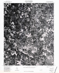 1980 Chapel Hill1983 Print · USGSChapel Hill at the start of the 1980s is captured in high-resolution aerial imagery, showing the town's expansion into the surrounding Orange County woodlands. Trace the development of the university community near University Lake and the rural reaches of Eubanks.
 - 1984 Map of Chapel Hill, 1985 Print
 1984 Chapel Hill1985 Print · USGSNorth Carolina’s Piedmont and the northern reaches of the Uwharrie Mountains are captured here in the mid-eighties. Genealogists can trace family roots through rural landmarks like Union Chapel or locate old rail stops along the Seaboard line.
End of results
Showing maps 1-2 of 2
Frequently asked questions
- What are the different types of historical maps available for University Lake?
- What is the oldest map of University Lake?
- Where can I purchase historical maps of University Lake for my home or office?
- Where can I download high-res historical maps of University Lake?
- Are there historical topographic maps available for University Lake?
- Is there historical aerial imagery available for University Lake?
- Where are historical maps of University Lake sourced from?