1960s Maps of Cary, North Carolina
Explore 3 historic maps of Cary from the 1960s. These maps offer a rare glimpse into what life looked like during the 1960s — showing old roads, neighborhoods, homes, and landmarks that have changed or disappeared over time.
Whether you're researching your family's past, planning a metal detecting trip, or studying how Cary's landscape evolved across the 1960s, these high-resolution maps are a powerful tool for exploring the history of this region.
- Focus on a specific era: All maps on this page are from the 1960s, giving you a focused view of this time period.
- See what’s changed: Compare century-old streets, trails, and buildings to today's modern landscape using overlays and satellite layers.
- Research with precision: Use these maps for genealogy, historical research, land use analysis, or educational projects.
- View, download, or print: Maps are fully viewable online in high resolution, and can be downloaded or printed for your own records.
Start exploring Cary's history through authentic maps from the 1960s. This is your window into the past.
Cary, NC maps
(3)- 1964 Map of Lake Wheeler, 1965 Print
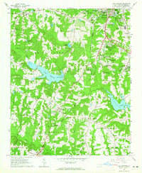 1964 Lake Wheeler1965 Print · USGSWake County south of the capital city shows a mix of rapid suburban growth and deep-rooted rural history during the mid-sixties. Genealogists and local historians can trace family sites like Franklin Cem alongside landmarks such as Yates Millpond and McCullers Crossroads.5 unique versions available
 - 1964 Map of Garner, 1965 Print
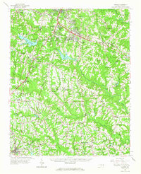 1964 Garner1965 Print · USGSThe rural landscapes south of Raleigh were transitioning from farm to suburb in the mid-sixties. Researchers can trace family roots at numerous country churches like Wooten Chapel Ch or locate sites such as McCullers, Willow Springs, and the historic McGee Mill.
 - 1968 Map of Raleigh West, 1972 Print
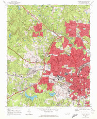 1968 Raleigh West1972 Print · USGSRaleigh in the late sixties reveals a city in rapid transition between its traditional downtown core and expanding suburban neighborhoods. Genealogists and historians can trace institutional landmarks like North Carolina State University alongside local settlements like Method and Asbury.6 unique versions available
End of results
Showing maps 1-3 of 3
Top cities near Cary
- Raleigh historical maps
- Durham historical maps
- Chapel Hill historical maps
- Apex historical maps
- Fuquay-Varina historical maps
- Garner historical maps
See more
Top neighborhoods of Cary
- Green Level historical maps
- Weston historical maps
- MacGregor Park historical maps
- Kildaire Farms historical maps
- Macedonia historical maps
- Knollwood historical maps
See more
Frequently asked questions
- What are the different types of historical maps available for Cary?
- What is the oldest map of Cary?
- Where can I purchase historical maps of Cary for my home or office?
- Where can I download high-res historical maps of Cary?
- Are there historical topographic maps available for Cary?
- Is there historical aerial imagery available for Cary?
- Where are historical maps of Cary sourced from?