1990s Maps of Faye & Michael J Riggs, Wake County
Explore 2 historic maps of Faye & Michael J Riggs from the 1990s. These maps offer a rare glimpse into what life looked like during the 1990s — showing old roads, neighborhoods, homes, and landmarks that have changed or disappeared over time.
Whether you're researching your family's past, planning a metal detecting trip, or studying how Faye & Michael J Riggs's landscape evolved across the 1990s, these high-resolution maps are a powerful tool for exploring the history of this region.
- Focus on a specific era: All maps on this page are from the 1990s, giving you a focused view of this time period.
- See what’s changed: Compare century-old streets, trails, and buildings to today's modern landscape using overlays and satellite layers.
- Research with precision: Use these maps for genealogy, historical research, land use analysis, or educational projects.
- View, download, or print: Maps are fully viewable online in high resolution, and can be downloaded or printed for your own records.
Start exploring Faye & Michael J Riggs's history through authentic maps from the 1990s. This is your window into the past.
Faye & Michael J Riggs, Wake County maps
(2)- 1991 Map of Henderson
 1991 Henderson1991 Print · USGSThe northern Piedmont and Virginia borderlands come into focus in the early nineties, showing a landscape defined by major reservoirs and growing towns. Trace the rail-and-road connections between Oxford, Henderson, and Durham while exploring the developing shores of Falls Lake.2 unique versions available
 - 1998 Map of Creedmoor, 2000 Print
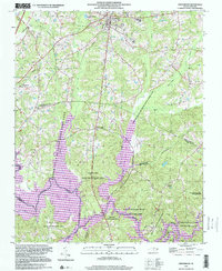 1998 Creedmoor2000 Print · USGSIn the late nineties, the area surrounding Creedmoor shows a landscape balancing small-town life with massive conservation tracts. Genealogists and historians can trace rail-side settlements like Northside and old community landmarks like New Light Ch and Ledge Rock.
End of results
Showing maps 1-2 of 2
Frequently asked questions
- What are the different types of historical maps available for Faye & Michael J Riggs?
- What is the oldest map of Faye & Michael J Riggs?
- Where can I purchase historical maps of Faye & Michael J Riggs for my home or office?
- Where can I download high-res historical maps of Faye & Michael J Riggs?
- Are there historical topographic maps available for Faye & Michael J Riggs?
- Is there historical aerial imagery available for Faye & Michael J Riggs?
- Where are historical maps of Faye & Michael J Riggs sourced from?