1960s Maps of Jimmie E. Wall, Raleigh
Explore 2 historic maps of Jimmie E. Wall from the 1960s. These maps offer a rare glimpse into what life looked like during the 1960s — showing old roads, neighborhoods, homes, and landmarks that have changed or disappeared over time.
Whether you're researching your family's past, planning a metal detecting trip, or studying how Jimmie E. Wall's landscape evolved across the 1960s, these high-resolution maps are a powerful tool for exploring the history of this region.
- Focus on a specific era: All maps on this page are from the 1960s, giving you a focused view of this time period.
- See what’s changed: Compare century-old streets, trails, and buildings to today's modern landscape using overlays and satellite layers.
- Research with precision: Use these maps for genealogy, historical research, land use analysis, or educational projects.
- View, download, or print: Maps are fully viewable online in high resolution, and can be downloaded or printed for your own records.
Start exploring Jimmie E. Wall's history through authentic maps from the 1960s. This is your window into the past.
Jimmie E. Wall, Raleigh maps
(2)- 1968 Map of Raleigh West, 1972 Print
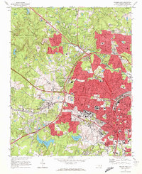 1968 Raleigh West1972 Print · USGSRaleigh in the late sixties reveals a city in rapid transition between its traditional downtown core and expanding suburban neighborhoods. Genealogists and historians can trace institutional landmarks like North Carolina State University alongside local settlements like Method and Asbury.6 unique versions available
 - 1968 Map of Raleigh East, 1972 Print
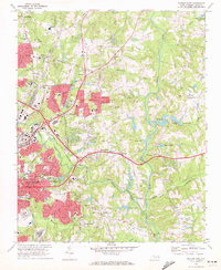 1968 Raleigh East1972 Print · USGSThe eastern expansion of Raleigh in the late sixties reveals a city emerging into the countryside near Milburnie and New Hope. Genealogists and historians can trace institutional sites like St Augustines College or local landmarks like Millbrook High Sch and Pet Crossroads.4 unique versions available
End of results
Showing maps 1-2 of 2
Frequently asked questions
- What are the different types of historical maps available for Jimmie E. Wall?
- What is the oldest map of Jimmie E. Wall?
- Where can I purchase historical maps of Jimmie E. Wall for my home or office?
- Where can I download high-res historical maps of Jimmie E. Wall?
- Are there historical topographic maps available for Jimmie E. Wall?
- Is there historical aerial imagery available for Jimmie E. Wall?
- Where are historical maps of Jimmie E. Wall sourced from?