1940s Maps of Watauga County, North Carolina
Explore 2 historic maps of Watauga County from the 1940s. These maps offer a rare glimpse into what life looked like during the 1940s — showing old roads, neighborhoods, homes, and landmarks that have changed or disappeared over time.
Whether you're researching your family's past, planning a metal detecting trip, or studying how Watauga County's landscape evolved across the 1940s, these high-resolution maps are a powerful tool for exploring the history of this region.
- Focus on a specific era: All maps on this page are from the 1940s, giving you a focused view of this time period.
- See what’s changed: Compare century-old streets, trails, and buildings to today's modern landscape using overlays and satellite layers.
- Research with precision: Use these maps for genealogy, historical research, land use analysis, or educational projects.
- View, download, or print: Maps are fully viewable online in high resolution, and can be downloaded or printed for your own records.
Start exploring Watauga County's history through authentic maps from the 1940s. This is your window into the past.
Watauga County, NC maps
(2)- 1942 Map of Blowing Rock
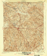 1942 Blowing Rock1942 Print · USGSWatauga and Caldwell Counties are shown here during the late nineteen-thirties and early forties, capturing the traditional highland communities and early development of the Blue Ridge Parkway. Genealogists can locate family landmarks like Shulls Mills, Poplar Grove Ch, and Liberty Hill Sch.4 unique versions available
 - 1944 Map of Linville
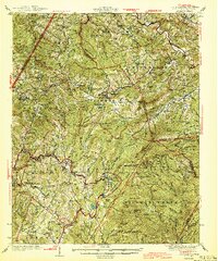 1944 Linville1944 Print · USGSThe High Country of Avery and Watauga Counties is shown here in the mid-1940s, anchored by the heights of Grandfather Mountain. Genealogists and local historians can trace the foundations of Banner Elk and Valle Crucis or locate rural landmarks like Sugar Mtn Sch and the Grandfather Orphanage.2 unique versions available
End of results
Showing maps 1-2 of 2
Top cities of Watauga County
Frequently asked questions
- What are the different types of historical maps available for Watauga County?
- What is the oldest map of Watauga County?
- Where can I purchase historical maps of Watauga County for my home or office?
- Where can I download high-res historical maps of Watauga County?
- Are there historical topographic maps available for Watauga County?
- Is there historical aerial imagery available for Watauga County?
- Where are historical maps of Watauga County sourced from?