Old Maps of Bamboo, Watauga County for Genealogy
Trace your family roots with 12 historic maps of Bamboo. These high-res maps reveal old neighborhoods, homesites, landmarks, and streets — helping you uncover where your ancestors lived and how the area evolved over time.
- Explore historic neighborhoods: Identify where your relatives may have lived in the 1800s or 1900s.
- Compare maps over time: Trace the changes in streets, buildings, and landmarks for multi-generational research.
- Perfect for genealogy & ancestry research: Used by family historians and researchers to map out lineage and migration.
These maps are an incredible resource for exploring your personal connection to Bamboo's past.
Bamboo, Watauga County maps
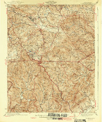
(12)- 1893 Map of Cranberry
 1893 Cranberry1893 Print · USGSCovers Bamboo, including Boone, Mountain City, and other nearby areas
 - 1895 Map of Cranberry
 1895 Cranberry1895 Print · USGSCovers Bamboo, including Boone, Mountain City, and other nearby areas
 - 1899 Map of Cranberry
 1899 Cranberry1899 Print · USGSCovers Bamboo, including Boone, Mountain City, and other nearby areas
 - 1902 Map of Cranberry
 1902 Cranberry1902 Print · USGSCovers Bamboo, including Boone, Mountain City, and other nearby areas6 unique versions available
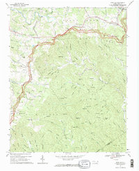
 - 1936 Map of Blowing Rock
 1936 Blowing Rock1936 Print · USGSCovers Bamboo, including Boone, Blowing Rock, and other nearby areas
 - 1942 Map of Blowing Rock
 1942 Blowing Rock1942 Print · USGSCovers Bamboo, including Boone, Blowing Rock, and other nearby areas4 unique versions available
 - 1953 Map of Winston-Salem, 1974 Print
 1953 Winston-Salem1974 Print · USGSCovers Bamboo, including Greensboro, Winston-Salem, and other nearby areas2 unique versions available
 - 1955 Map of Winston-Salem
 1955 Winston-Salem1955 Print · USGSCovers Bamboo, including Greensboro, Winston-Salem, and other nearby areas
 - 1962 Map of Winston-Salem
 1962 Winston-Salem1962 Print · USGSCovers Bamboo, including Greensboro, Winston-Salem, and other nearby areas
 - 1967 Map of Deep Gap, 1969 Print
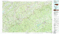
 1967 Deep Gap1969 Print · USGSCovers Bamboo, including Boone, Powderhorn Mountain, and other nearby areas2 unique versions available
 - 1985 Map of Boone, 1986 Print
 1985 Boone1986 Print · USGSCovers Bamboo, including Boone, North Wilkesboro, and other nearby areas2 unique versions available
 - 1998 Map of Deep Gap, 1999 Print
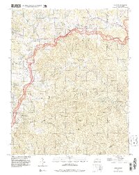 1998 Deep Gap1999 Print · USGSCovers Bamboo, including Boone, Powderhorn Mountain, and other nearby areas
End of results
Showing maps 1-12 of 12
Frequently asked questions
- What are the different types of historical maps available for Bamboo?
- What is the oldest map of Bamboo?
- Where can I purchase historical maps of Bamboo for my home or office?
- Where can I download high-res historical maps of Bamboo?
- Are there historical topographic maps available for Bamboo?
- Is there historical aerial imagery available for Bamboo?
- Where are historical maps of Bamboo sourced from?