1990s Maps of Yadkin County, North Carolina
Explore 7 historic maps of Yadkin County from the 1990s. These maps offer a rare glimpse into what life looked like during the 1990s — showing old roads, neighborhoods, homes, and landmarks that have changed or disappeared over time.
Whether you're researching your family's past, planning a metal detecting trip, or studying how Yadkin County's landscape evolved across the 1990s, these high-resolution maps are a powerful tool for exploring the history of this region.
- Focus on a specific era: All maps on this page are from the 1990s, giving you a focused view of this time period.
- See what’s changed: Compare century-old streets, trails, and buildings to today's modern landscape using overlays and satellite layers.
- Research with precision: Use these maps for genealogy, historical research, land use analysis, or educational projects.
- View, download, or print: Maps are fully viewable online in high resolution, and can be downloaded or printed for your own records.
Start exploring Yadkin County's history through authentic maps from the 1990s. This is your window into the past.
Yadkin County, NC maps
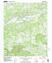
(7)- 1996 Map of East Bend, 2000 Print
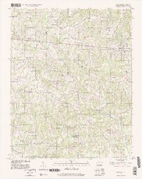 1996 East Bend2000 Print · USGSYadkin County's rolling landscape is shown here in the mid-nineties, centering on the rural community of East Bend. Genealogists and local historians can trace family locations near Half Creek Tabernacle, Richmond Hill, and Smithtown.
 - 1996 Map of Elkin South, 2000 Print
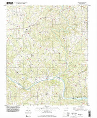
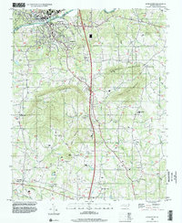 1996 Elkin South2000 Print · USGSThe riverfront towns of Jonesville and Elkin meet at the Yadkin River in the mid-1990s, where the rising peaks of the Brushy Mountains define the rural landscape. Genealogists can locate family landmarks like Mountain Grove Ch Cem, Starmount High Sch, and the small airfield at Swan Creek Airport.
 - 1996 Map of Brooks Crossroads, 2000 Print
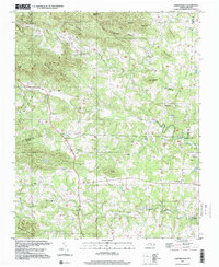
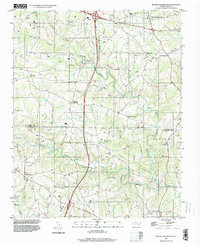 1996 Brooks Crossroads2000 Print · USGSNorth Carolina's Piedmont hills show a blend of old crossroads communities and modern highway development in the mid-nineties. Trace family roots at Wesley Chapel, Brooks Crossroads, or Eagle Mills while following the many branches of Hunting Creek.
 - 1997 Map of Vienna, 2000 Print
 1997 Vienna2000 Print · USGSThe Yadkin River valley in the late 1990s reveals a landscape of enduring rural communities and family landmarks. Genealogists and local historians can trace the foundations of Vienna, East Bend, and Seward through features like Union Hill, the Benbow Chapel, and the Old Richmond Sch.
 - 1997 Map of Ronda, 2000 Print
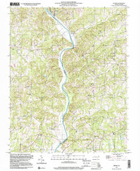
 1997 Ronda2000 Print · USGSThe Yadkin River valley in the late 1990s is captured here, showing the communities of Ronda and Roaring River amidst the southern ridges. Researchers can trace local roots through numerous landmarks like Brier Creek Cem, Poplar Springs Ch, and East Wilkes High Sch.
 - 1997 Map of Siloam, 2000 Print
 1997 Siloam2000 Print · USGSSurry and Yadkin counties appear in the late 1990s as a landscape of river-valley settlements and rural congregations. Genealogists can trace family footprints around Old Siloam, Stanford Ch, and the landmark Pinnacle View Ch.
 - 1997 Map of Osbornville, 2000 Print
 1997 Osbornville2000 Print · USGSOsbornville and the eastern Brushy Mountains are shown at the end of the century as a network of crossroads communities and highland farms. Genealogists can trace family footprints near Smyrna Chapel, Somers Crossroads, and the rural homes surrounding New Hope.
End of results
Showing maps 1-7 of 7
Top cities of Yadkin County
- Yadkinville historical maps
- Jonesville historical maps
- Boonville historical maps
- East Bend historical maps
Frequently asked questions
- What are the different types of historical maps available for Yadkin County?
- What is the oldest map of Yadkin County?
- Where can I purchase historical maps of Yadkin County for my home or office?
- Where can I download high-res historical maps of Yadkin County?
- Are there historical topographic maps available for Yadkin County?
- Is there historical aerial imagery available for Yadkin County?
- Where are historical maps of Yadkin County sourced from?