1900s (20th Century) Maps of Ochoco Pointe, Prineville
Explore 7 historic maps of Ochoco Pointe from the 1900s (20th Century). These maps offer a rare glimpse into what life looked like during the 1900s — showing old roads, neighborhoods, homes, and landmarks that have changed or disappeared over time.
Whether you're researching your family's past, planning a metal detecting trip, or studying how Ochoco Pointe's landscape evolved across the 1900s, these high-resolution maps are a powerful tool for exploring the history of this region.
- Focus on a specific era: All maps on this page are from the 1900s, giving you a focused view of this time period.
- See what’s changed: Compare century-old streets, trails, and buildings to today's modern landscape using overlays and satellite layers.
- Research with precision: Use these maps for genealogy, historical research, land use analysis, or educational projects.
- View, download, or print: Maps are fully viewable online in high resolution, and can be downloaded or printed for your own records.
Start exploring Ochoco Pointe's history through authentic maps from the 1900s. This is your window into the past.
Ochoco Pointe, Prineville maps
(7)- 1955 Map of Bend, 1964 Print
 1955 Bend1964 Print · USGSCentral Oregon was undergoing significant growth in the mid-1960s as irrigation and infrastructure transformed the high desert. Researchers can trace the path of the Oregon Trunk Line, locate old stops like Gateway, and find landmarks like Lava Butte or the Grange.3 unique versions available
 - 1957 Map of Bend
 1957 Bend1957 Print · USGSCentral Oregon in the mid-fifties is a landscape of transition between the high Cascades and the arid volcanic plateau. Local historians can trace the rail corridors of the Oregon Trunk and locate early settlements like Ashwood, Odin Falls, and Camp Sherman.
 - 1958 Map of Bend
 1958 Bend1958 Print · USGSCentral Oregon in the late fifties was a land of high desert ranching and growing mountain towns. Researchers can trace the rail lines of the Oregon Trunk Railroad, find established settlements like Madras and Sisters, or locate landmarks such as Smith Rock and Lava Butte.
 - 1962 Map of Prineville, 1963 Print
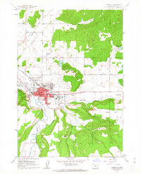 1962 Prineville1963 Print · USGSPrineville and the surrounding high desert valleys are shown in detail during the early sixties, highlighting a landscape defined by river irrigation and central Oregon ranching life. Researchers can trace the town's development through landmarks like the Courthouse, Ochoco Sch, and the Pioneer Memorial Hospital.
 - 1962 Map of Prineville, 1964 Print
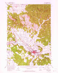 1962 Prineville1964 Print · USGSCentral Oregon in the early 1960s shows a landscape of river-valley agriculture and rugged uplands centering on the growing city of Prineville. Genealogists and local historians can trace rural infrastructure from Lamonta to the Upper McKay Sch and the various Cinder Pits dotting the volcanic buttes.2 unique versions available
 - 1981 Map of Prineville
 1981 Prineville1981 Print · USGSPrineville and the Crooked River valley are seen here in the early eighties as the region balanced timber, ranching, and new water management projects. Genealogists and local historians can trace family-named landmarks like Watkins, locate the Cem, or find old mining sites such as the Amity Mine.
 - 1992 Map of Prineville, 1997 Print
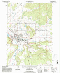 1992 Prineville1997 Print · USGSPrineville and its surrounding irrigation network are captured here in the early 1990s, showcasing the town's role as a regional hub. Researchers can trace the legacy of the high desert community through landmarks like the Crook County High Sch, the Courthouse, and O'Neil.
End of results
Showing maps 1-7 of 7
Frequently asked questions
- What are the different types of historical maps available for Ochoco Pointe?
- What is the oldest map of Ochoco Pointe?
- Where can I purchase historical maps of Ochoco Pointe for my home or office?
- Where can I download high-res historical maps of Ochoco Pointe?
- Are there historical topographic maps available for Ochoco Pointe?
- Is there historical aerial imagery available for Ochoco Pointe?
- Where are historical maps of Ochoco Pointe sourced from?