Old Maps of Prairie City, Oregon for Academic Research
Study the evolution of Prairie City with 11 high-resolution historic maps. Whether you're teaching, researching, or modeling changes in land use, these maps provide essential visual documentation of urban, environmental, and geographic change.
- Analyze long-term change: Track patterns in development, transportation, and natural features.
- Ideal for environmental or urban studies: Support academic projects with primary historical map data.
- Use in the classroom or lab: Educators and researchers rely on these maps to bring historical context to life.
These maps are a powerful tool for teaching, research, and visualizing how Prairie City has changed over the decades.
Prairie City, OR maps
(11)- 1955 Map of Canyon City, 1966 Print
 1955 Canyon City1966 Print · USGSCentral Oregon's high desert and timber country are captured here in the mid-fifties, showing the rugged ranching and logging landscape. Trace the path of the Sumpter Valley Ry or locate remote settlements like Izee, Whitney, and Ritter.4 unique versions available
 - 1959 Map of Canyon City
 1959 Canyon City1959 Print · USGSEastern Oregon in the late fifties was a landscape of high timber and remote river valleys shaped by the cattle and mining trades. Genealogists and historians can trace the paths of the Sumpter Valley RR and find early settlements like Antone, Richmond, and Dayville.2 unique versions available
 - 1959 Map of Prairie City, 1960 Print
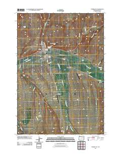
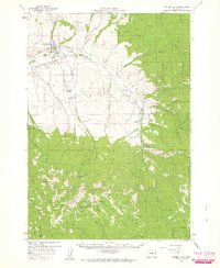 1959 Prairie City1960 Print · USGSPrairie City and the upper John Day River valley are captured in the late fifties as ranching and timber define the local economy. Researchers can locate the Cemetery, follow the Ditch to Oxbow Ranch, or trace the remote Maude Thompson Mine and Blue Mtn Hot Springs.4 unique versions available
 - 1978 Map of John Day, 1997 Print
 1978 John Day1997 Print · USGSEastern Oregon in the late 1970s shows a landscape defined by timber, mining, and high-desert hydrology. Researchers can trace the legacy of the Standard Mine, the route of the Oregon and Northwestern Railroad, and the remote outposts of Seneca and Prairie City.2 unique versions available
 - 1988 Map of Prairie City
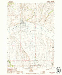 1988 Prairie City1988 Print · USGSPrairie City and the surrounding Grant County ranchlands are documented here in the late eighties during a period of steady agricultural and industrial use. Researchers can trace the legacy of resource extraction through Dredge Tailings along the John Day River or locate historic holdings like Oxbow Ranch.
 - 1996 Map of Prairie City, 1998 Print
 1996 Prairie City1998 Print · USGSGrant County ranching and mining history come into focus in the mid-1990s as the town of Prairie City meets the mountain gulches. Researchers can locate the Prairie City Cem, trace Indian Creek, and identify industrial Dredge Tailings or the Ray Ranch.
 - 2011 Map of Prairie City, 2011 Print
 2011 Prairie City2011 Print · USGSCovers Prairie City, including Grant County, United States, and other nearby areas
 - 2014 Map of Prairie City, 2014 Print
 2014 Prairie City2014 Print · USGSCovers Prairie City, including Grant County, United States, and other nearby areas
 - 2017 Map of Prairie City, 2017 Print
 2017 Prairie City2017 Print · USGSCovers Prairie City, including Grant County, United States, and other nearby areas
 - 2020 Map of Prairie City, 2020 Print
 2020 Prairie City2020 Print · USGSCovers Prairie City, including Grant County, United States, and other nearby areas
 - 2023 Map of Prairie City, 2023 Print
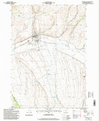
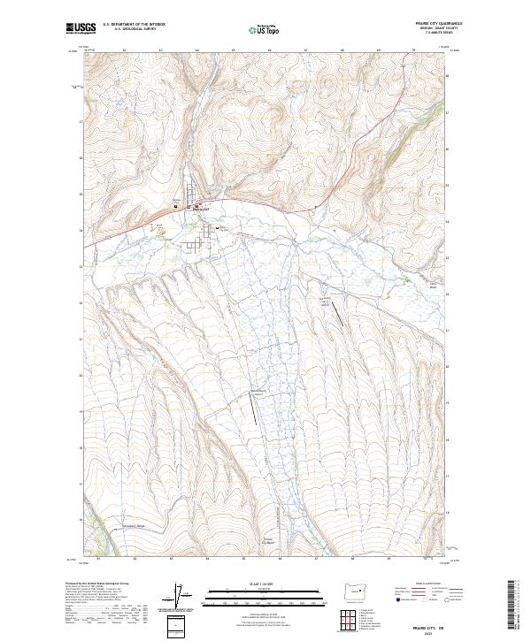 2023 Prairie City2023 Print · USGSPrairie City sits at the junction of the John Day River and Dixie Creek in this recent Grant County survey. Genealogists and local historians can trace family roots at McHaley Cem and Prairie City Cem or follow the path of The Mill Ditch.
End of results
Showing maps 1-11 of 11
Top cities near Prairie City
Frequently asked questions
- What are the different types of historical maps available for Prairie City?
- What is the oldest map of Prairie City?
- Where can I purchase historical maps of Prairie City for my home or office?
- Where can I download high-res historical maps of Prairie City?
- Are there historical topographic maps available for Prairie City?
- Is there historical aerial imagery available for Prairie City?
- Where are historical maps of Prairie City sourced from?