1990s Maps of Chiloquin, Oregon
Explore 2 historic maps of Chiloquin from the 1990s. These maps offer a rare glimpse into what life looked like during the 1990s — showing old roads, neighborhoods, homes, and landmarks that have changed or disappeared over time.
Whether you're researching your family's past, planning a metal detecting trip, or studying how Chiloquin's landscape evolved across the 1990s, these high-resolution maps are a powerful tool for exploring the history of this region.
- Focus on a specific era: All maps on this page are from the 1990s, giving you a focused view of this time period.
- See what’s changed: Compare century-old streets, trails, and buildings to today's modern landscape using overlays and satellite layers.
- Research with precision: Use these maps for genealogy, historical research, land use analysis, or educational projects.
- View, download, or print: Maps are fully viewable online in high resolution, and can be downloaded or printed for your own records.
Start exploring Chiloquin's history through authentic maps from the 1990s. This is your window into the past.
Chiloquin, OR maps
(2)- 1998 Map of Agency Lake, 2000 Print
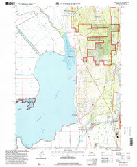 1998 Agency Lake2000 Print · USGSThe Klamath Basin is captured here in the late nineties, showing a landscape of sprawling wetlands and forest boundaries. Researchers can trace the Modoc Point Main Line railroad past Klamath Agency, Lobert Cem, and the Williamson River Mission.
 - 1998 Map of Chiloquin, 2000 Print
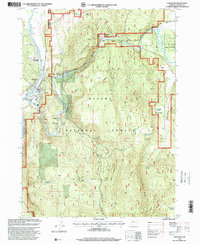 1998 Chiloquin2000 Print · USGSChiloquin and the surrounding river valleys are captured here in the late nineties, showcasing the intersection of tribal trust lands and national forest. Genealogists and historians can locate Friendship Cemetery, the historic Braymill area, and the former settlement at Meva (Site).
End of results
Showing maps 1-2 of 2
Frequently asked questions
- What are the different types of historical maps available for Chiloquin?
- What is the oldest map of Chiloquin?
- Where can I purchase historical maps of Chiloquin for my home or office?
- Where can I download high-res historical maps of Chiloquin?
- Are there historical topographic maps available for Chiloquin?
- Is there historical aerial imagery available for Chiloquin?
- Where are historical maps of Chiloquin sourced from?