1980s Maps of Creswell, Oregon
Explore 3 historic maps of Creswell from the 1980s. These maps offer a rare glimpse into what life looked like during the 1980s — showing old roads, neighborhoods, homes, and landmarks that have changed or disappeared over time.
Whether you're researching your family's past, planning a metal detecting trip, or studying how Creswell's landscape evolved across the 1980s, these high-resolution maps are a powerful tool for exploring the history of this region.
- Focus on a specific era: All maps on this page are from the 1980s, giving you a focused view of this time period.
- See what’s changed: Compare century-old streets, trails, and buildings to today's modern landscape using overlays and satellite layers.
- Research with precision: Use these maps for genealogy, historical research, land use analysis, or educational projects.
- View, download, or print: Maps are fully viewable online in high resolution, and can be downloaded or printed for your own records.
Start exploring Creswell's history through authentic maps from the 1980s. This is your window into the past.
Creswell, OR maps
(3)- 1983 Map of Oakridge
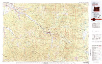 1983 Oakridge1983 Print · USGSThe Cascades of Lane County are shown in the early eighties, centered on the timber and rail corridors of the Willamette. Genealogists and historians can trace the Southern Pacific line through Oakridge or find old mining sites like Mayflower Mine.
 - 1984 Map of Creswell
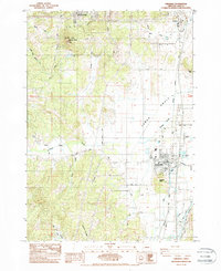 1984 Creswell1984 Print · USGSThe southern Willamette Valley transitions from agricultural flats to the foothills of the Cascades in the early 1980s. Researchers can trace family history at the Moxley Cem, locate rural homesteads along Kuni Rd, and follow the Southern Pacific rail line through Creswell.2 unique versions available
 - 1986 Map of Jasper
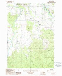 1986 Jasper1986 Print · USGSLane County in the mid-1980s shows the convergence of the Willamette River forks near the community of Jasper. Researchers can trace local landmarks like Pleasant Hill Sch, family-named summits such as Sellers Butte, and several active Quarry sites.
End of results
Showing maps 1-3 of 3
Top cities near Creswell
- Eugene historical maps
- Springfield historical maps
- Cottage Grove historical maps
- Coburg historical maps
- Lowell historical maps
- Malabon historical maps
Frequently asked questions
- What are the different types of historical maps available for Creswell?
- What is the oldest map of Creswell?
- Where can I purchase historical maps of Creswell for my home or office?
- Where can I download high-res historical maps of Creswell?
- Are there historical topographic maps available for Creswell?
- Is there historical aerial imagery available for Creswell?
- Where are historical maps of Creswell sourced from?